
 English
 Français

Errol, Perth and Kinross
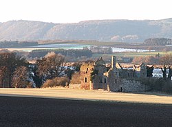
Errol is a village in Perth and Kinross, Scotland, about halfway between Dundee and Perth. It is one of the principal settlements of the Carse of Gowrie. It lies just north of the River Tay. The 2016 population of Errol was estimated to be 1,500 persons, compared to 1,070 in the 2001 Census and 1,311 in the 2011 Census. Errol village is in the Carse and Gowrie electoral ward of the Perthshire North Scottish parliamentary constituency and in the Tayside Health Board area. Errol is twinned with Mardié, a village on the Loire near Orléans in France. Errol is surrounded by agricultural flat fields and has a prominent attractive location above the Firth of Tay within this setting. Errol is known for its reeds, which used to be collected up to a few years ago to make thatched roofs. These reeds grow in the banks of the River Tay and act as home to a fairly uncommon bird called the bearded tit or bearded reedling. Errol has a large church, built in 1831, known as the "Cathedral of The Carse" which can be seen from most parts of the village and from far around. Errol lies on the National Cycle Network NCN 77 from Dundee to Pitlochry and is situated about 1 mile (1.5 kilometres) from the A90 Perth to Dundee Road. This makes it popular for people who commute to work whilst maintaining a vibrant local community including the Church, the village hall, the bowling club, village pub, Lass O'Gowrie Cafe, an annual gala, Twinning Society, Take a Pride in Errol, and various other services/activities/groups (see below).
Lieux à Proximité Voir Menu
Château de Ballinbreich

Newburgh (Fife)


Earn
