
 English
 Français

Witherwack
Witherwack is a suburb in the north of Sunderland, England, situated between Red House to the west, Carley Hill to the east and Marley Pots to the south. The origin of the name Witherwack is unknown. The spelling of the name has changed since the Ordnance Survey maps of 1862 (and as late as 1945) on which it was spelled Whitherwhack. The area is an overspill council estate, usually regarded as part of Greater Southwick, and was built in the 1960s. In common with most estates in Sunderland, the street names all start with the same letter - 'W' in the case of Witherwack. The whole of the estate falls within the SR5 postal code. It is represented by three Labour councillors as part of the Southwick ward on Sunderland City Council.
Lieux à Proximité Voir Menu

2.1 km
Newcastle Road
Newcastle Road était un stade de football situé à Sunderland, en Angleterre. C'est le terrain du Sunderland AFC entre 1886 et 1898.
2.1 km
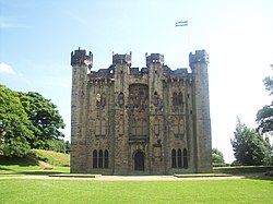
Château de Hylton
Le château de Hylton est un château en pierre, actuellement en ruine, situé près de Sunderland dans le Tyne and Wear en Angleterre. Construit à l'origine en bois, par un des baron Hylton, juste après la conquête normande de l'Angleterre. Il est reconstruit en pierre de la fin du XIVe jusqu'au début du XVe siècle.
Le château a ensuite subi d'importantes modifications aux XVIIIe et XIXe siècles. Il sert divers usages après la fin de la maison Hylton en 1746, le bâtiment a été négligé puis est devenu une école en 1840, avant appartenir à une société houillère au XXe siècle, pour enfin être pris en charge par l'État en 1950, pour enfin appartenir aujourd'hui à l'English Heritage, organisme public chargé du patrimoine historique.
Le château est réputé hanté par le Cauld Lad of Hylton.

2.3 km
Stadium of Light
Le Stadium of Light est le stade de football du Sunderland AFC.
Ce stade de 48 353 places est inauguré en 1997, par le prince Andrew, duc d'York, à l'occasion d'une rencontre entre le Sunderland AFC et l'Ajax Amsterdam.
2.6 km
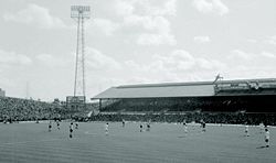
Roker Park
Roker Park était un stade de football localisé à Sunderland, en Angleterre. C'est l'enceinte du club du Sunderland AFC entre 1898 et 1997.

2.9 km
Cité de Sunderland
La Cité de Sunderland (en anglais : City of Sunderland) est un district du Tyne and Wear, en Angleterre. Elle a le statut de district métropolitain et de cité (city). Elle porte le nom de sa principale ville, Sunderland, et couvre un territoire comprenant les villes de Hetton-le-Hole, Houghton-le-Spring, Washington, ainsi que des villages suburbains.
Le district a été créé en 1974 sous le nom de District métropolitain de Sunderland (Metropolitan Borough of Sunderland) par le Local Government Act 1972. Il est issu de la fusion de quatre anciens districts du comté de Durham. Il a reçu le statut de cité en 1992, à l'occasion du 40e anniversaire de l'accession au trône de la reine Élisabeth II.
Au recensement de 2001, la cité de Sunderland comptait 280 807 habitants, dont une majorité réside à Sunderland.