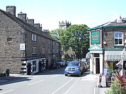
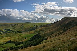
The Peak District is an upland area in central-northern England, at the southern end of the Pennines. Mostly in Derbyshire, it extends into Cheshire, Greater Manchester, Staffordshire, West Yorkshire and South Yorkshire. It is subdivided into the Dark Peak, moorland dominated by gritstone, and the White Peak, a limestone area with valleys and gorges. The Dark Peak forms an arc on the north, east and west of the district, and the White Peak covers central and southern areas. The highest point is Kinder Scout (2,087 ft (636 m)). Most of the area is within the Peak District National Park, a protected landscape designated in 1951. A 2021 report states that "the Park's own population numbers around 40,000 and supports an estimated 18,000 jobs, predominantly through farming, manufacturing and, inevitably, tourism". The area has been inhabited since the Mesolithic era; it was largely used for agricultural purposes until mining arose in the Middle Ages. During the Industrial Revolution, several cotton mills were constructed in the area's valleys by Richard Arkwright. As mining declined, quarrying grew. Tourism came with the railways, spurred by the landscape, spa towns and Castleton's show caves.

Lieux à Proximité Voir Menu
Location Image
40 m

Kinder Scout

Kinder Scout est un sommet du Royaume-Uni culminant à 636 mètres d'altitude dans la chaîne des Pennines, dans le comté de Derbyshire, dont il constitue le point culminant, en Angleterre. C'est également le plus haut sommet du Peak District. Il présente la forme d'un vaste plateau entouré de parois verticales d'où se précipitent quelques cascades. Prisé des randonneurs et des grimpeurs, il a joué un rôle important dans l'ouverture de droits de passage et la création de parcs nationaux en Angleterre. Il fait également partie d'une réserve de nature et de différentes zones protégées.
Location Image
4.2 km

High Peak (Derbyshire)

High Peak est un district non-métropolitain du Derbyshire, en Angleterre. Le conseil de district siège à Buxton. L'ancien hundred de High Peak couvrait un territoire similaire à l'actuel district. Celui-ci a été créé le 1er avril 1964. Il est issu de la fusion des districts municipaux de Buxton et Glossop, des districts urbains de New Mills et Whaley Bridge, et du district rural de Chapel-en-le-Frith, qui faisaient auparavant tous partie du comté administratif du Derbyshire, ainsi que des districts ruraux de Tintwistle et Woodhead, qui faisaient partie du comté administratif du Cheshire.
Location Image
4.4 km

Edale

Edale est une paroisse civile et un village du Derbyshire, en Angleterre.
Location Image
4.4 km

Hayfield (Derbyshire)

Hayfield est une paroisse civile et un village du Derbyshire, en Angleterre.
Location Image
5.7 km

Chinley, Buxworth and Brownside

Chinley, Buxworth and Brownside est une paroisse civile du Derbyshire, en Angleterre.