
 English
 Français

Atherton, Greater Manchester
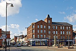
Atherton () is a town in the Metropolitan Borough of Wigan in Greater Manchester, England and historically part of Lancashire. The town, including Hindsford, Howe Bridge and Hag Fold, is five miles (eight kilometres) south of Bolton, seven miles (eleven kilometres) east of Wigan, and 10 miles (16 kilometres) northwest of Manchester. From the 17th century, for about 300 years, Atherton was known as Chowbent, which was frequently shortened to Bent, the town's old nickname. During the Industrial Revolution, the town was a key part of the Manchester Coalfield. Atherton was associated with coal mining and nail manufacture from the 14th century, encouraged by outcropping coal seams. At the beginning of the 20th century, the town was described as "the centre of a district of collieries, cotton mills and iron-works, which cover the surface of the country with their inartistic buildings and surroundings, and are linked together by the equally unlovely dwellings of the people". Atherton's last deep coal mine closed in 1966, and the last cotton mill closed in 1999. Today the town is the third-largest retail centre in the Borough of Wigan; almost 20% of those employed in the area work in the wholesale and retail trades, although there is still some significant manufacturing industry in the town. Evidence has been discovered of a Roman road passing through the area, on the ancient route between Coccium (Wigan) and Mamucium (Manchester). Following the Anglo-Saxon invasion of England, Atherton, which is built on and around seven brooks, became part of the manor of Warrington until the Norman Conquest, when it became a township or vill in the ancient parish of Leigh. Since 1974 the town has been part of the Metropolitan Borough of Wigan, a local government district of the Metropolitan County of Greater Manchester and since 2024 it has been part of the Leigh and Atherton parliamentary constituency.
Lieux à Proximité Voir Menu
Atherton (Grand Manchester)

Leigh (Grand Manchester)
Bedford (Grand Manchester)
