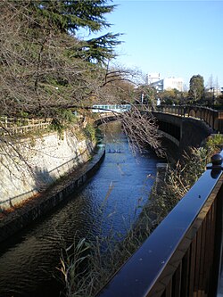
The Myōshōji River (妙正寺川, Myōshōji-gawa) is designated as a Class A river by the Japanese government with a length of 9.7 km and a basin area of 21.4 km².
Réserver votre visite près de
Myōshōji River
Réserver
4,0
en partenariat avec
GetYourGuide.com
Localisation
2 explorateurs ont visité ce lieu

198 m
La gare de Shimo-Ochiai est une gare ferroviaire de l'arrondissement de Shinjuku, à Tokyo au Japon. Elle est exploitée par la compagnie Seibu.
646 m
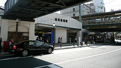
La gare de Takadanobaba est une gare ferroviaire de la ville de Tokyo au Japon. Elle est située dans l'arrondissement de Shinjuku, dans le quartier de Takadanobaba. Elle est desservie par les lignes des compagnies JR East, Seibu et Tokyo Metro.

646 m
Takadanobaba est un quartier de l'arrondissement de Shinjuku à Tōkyō, au Japon. Il s'articule principalement autour des deux rues Waseda-dôri et Meiji-dôri.
Le nom originel de ce quartier était Takatanobaba et des Edokko âgés le disent toujours. Les Edokko plus jeunes et ceux qui viennent de l'extérieur de Tokyo disent Takadanobaba. Le quartier est aussi connu sous le nom de Baba.
La communauté birmane en exil au Japon est basée à Baba. On trouve des restaurants, magasins, et des organisations qui travaillent avec les Birmans.
Baba est aussi un quartier des étudiants avec plusieurs bars et izakaya. L'université Waseda et l'université Gakushūin sont près de Baba.
Astro Boy de Osamu Tezuka y est né comme en témoigne la musique de l'arrêt Takadanobaba de la ligne Yamanote.
823 m
La bibliothèque braille du Japon est une bibliothèque spécialisée dans la littérature en braille et les services pour les personnes aveugles ou malvoyants, située à Tokyo, au Japon.

983 m
La gare de Nakai est une gare ferroviaire située dans l'arrondissement de Shinjuku à Tokyo au Japon. Cette gare est exploitée conjointement par les compagnies Seibu et Toei.
Course
It starts in the Myōshōji Temple pond in Suginami Ward, and joins the Egota River later on. It flows into the Kanda River (Takadanobaba Channel) in Shinjuku Ward.
Recent history
Due to the progress of urbanization, the water retention capacity of the Myōshōji River has fallen and there is an increasing risk of water damage. To cope with this situation, the Tokyo Metropolitan Government has constructed revetments that can handle rainfall of up to 50 millimeters per hour.
References
kensetsu.metro.tokyo.jp