


Scarborough—Rouge Park is a former federal electoral district in Ontario, Canada, that was represented in the House of Commons of Canada from 2015 to 2025. Scarborough—Rouge Park was created by the 2012 federal electoral boundaries redistribution and was legally defined in the 2013 representation order. It came into effect upon the call of the 42nd Canadian federal election that took place on October 19, 2015.
Localisation
1 explorateur a visité ce lieu


It was created out of parts of the electoral districts of Pickering—Scarborough East (49%), Scarborough—Rouge River (36%) and Scarborough—Guildwood (14%).
Geography
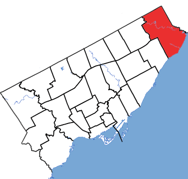
The riding consists of the eastern part of the Scarborough district of Toronto. It contains the neighbourhoods of Rouge, Port Union, West Rouge, Highland Creek, West Hill (east of Morningside Avenue) and Malvern (east of Neilson Road).
Demographics
According to the 2021 Canadian census Ethnic groups: 35.4% South Asian, 23.6% White, 15.0% Black, 8.9% Filipino, 4.4% Chinese, 1.4% Latin American, 1.3% West Asian, 1.1% Southeast Asian, 1.0% Arab Languages: 55.2% English, 10.6% Tamil, 4.3% Tagalog, 1.9% Bengali, 2.1% Urdu, 1.8% Cantonese, 1.5% Punjabi, 1.4% Gujarati, 1.1% Mandarin, 1.0% Hindi Religions: 47.9% Christian (22.9% Catholic, 2.8% Anglican, 2.5% Christian Orthodox, 2.5% Pentecostal, 1.3% United Church, 1.2% Baptist, 1.1% Presbyterian, 13.6% Other), 20.0% Hindu, 12.0% Muslim, 1.4% Sikh, 1.1% Buddhist, 17.0% None Median income: $37,200 (2020) Average income: $47,840 (2020)
Members of Parliament
This riding has elected the following members of Parliament:
See also
List of Canadian electoral districts Historical federal electoral districts of Canada