


L'abbaye de Beaupré était située autrefois à Grimminge, en Belgique, sur la Dendre, non loin de Grammont. Les bâtiments subsistants font aujourd'hui partie d'un domaine privé. L'abbaye est fondée en 1228, détruite au XVIe siècle lors des révoltes des gueux et reconstruite en 1590. La Révolution française sonne définitivement le glas de l'abbaye.
Location
1 explorer visited this place

2.2 km
Raspaillebos is a forest area in the Flemish Ardennes in the south of the Belgian province of East Flanders. The forest area of 50 hectares is located on the territory of the municipality of Geraardsbergen, near the provincial border with Galmaarden in Flemish Brabant. Raspaillebos connects to Moerbekebos, to the Flemish forest reserve Karkoolbos, and also to the forest area Kluysbos in Galmaarden. Raspaillebos is managed by the Flemish government agency Agency for Nature and Forest and by Natuurpunt. The nature reserve holds European recognition as a Natura 2000 area and is part of the Flemish Ecological Network. The area has been a protected landscape since 1980 and is also recognized as a quiet area.

4.0 km
The Muur van Geraardsbergen is a steep, narrow road with cobblestones in Geraardsbergen, Belgium. It is also known as Kapelmuur, Muur-Kapelmuur or simply Muur. The hill starts near the river Dender at 18 m and reaches the top of the Oudenberg at 110 m after 1,075 m at 9.3 per cent. This climb is often part of the Tour of Flanders professional cycling race.

4.1 km
Boelare Castle is a castle near the village Nederboelare, Geraardsbergen municipality, in the province of East Flanders, Belgium. It used to be the seat of the feudal domain Land and Barony of Boelare. The oldest recording of the name Boelare dates back to the 11th century, but the domain is probably older.
Some indications point to a first castle in Boelare in the 9th century. However, the structure of the current castle buildings dates back to 1605. On 1 July 1987 the castle was classified as an important national treasure by the Belgian government. In 1983, the buildings were renovated, and are currently housing a home for elderly people.

5.7 km
The 1964 UCI Cyclo-cross World Championships were held in Overboelare, Belgium on Sunday February 16, 1964. It was the 15th edition of the UCI Cyclo-cross World Championships.
The race took place on the right side of the Dender river, with the start on the site of today's airfield and a detour to the Boelare forest. There were seven laps of a 3.1 km long course, which, together with an inrun section at the start, resulted in a total length of 23,050 m. The course was considered to be rather easy in advance, but this was not the case on site, also because rain softened the course before and during the race.
From the third lap onwards, Renato Longo took the lead, which no one would challenge him anymore; he won his third title in a dominant manner. Behind him the positions changed frequently, and a group of four riders ended up fighting for the medals. Home rider Roger De Clercq, who had been in the top ten many times since 1953, came second and was on the podium for the first time. For third-placed Joseph Mahé, however, it was his first World Championship participation.
For the first time at the World Championships, all riders who started reached the finish.
5.7 km
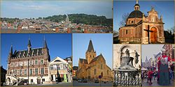
Geraardsbergen] ; French: Grammont [ɡʁamɔ̃]) is a city and municipality located in the Denderstreek and in the Flemish Ardennes, the hilly southern part of the Belgian province of East Flanders. The municipality comprises the city of Geraardsbergen proper and the following towns:
Goeferdinge, Grimminge, Idegem, Moerbeke, Nederboelare, Nieuwenhove, Onkerzele, Ophasselt, Overboelare, Schendelbeke, Smeerebbe-Vloerzegem, Viane, Waarbeke, Zandbergen and Zarlardinge.
In 2021, Geraardsbergen had a total population of 33,970. The total area is 79.71 km2.
The current mayor of Geraardsbergen is Ann Panis, from the party Open VLD.
Abatissa in "Bellum Pratum"
Les abbesses était élues de grandes familles, d'ancienne noblesse.