
 English
 Français

Lamachan Hill
Lamachan Hill is a hill in the Minnigaff Hills, a sub-range of the Galloway Hills range, part of the Southern Uplands of Scotland. It is the highest hill of the range, lying 11 kilometres (7 mi) north of Newton Stewart in Dumfries and Galloway.
Nearby Places View Menu

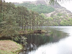
3.8 km
Round Loch of Glenhead
The Round Loch of Glenhead is a small upland single basin loch in Dumfries and Galloway. It is situated within Galloway Forest Park to the west of the hill Craiglee. It forms a pair with the nearby Long Loch of Glenhead. Both lochs are of similar sizes and each have a small island. The two lochs are separated from Loch Valley and Loch Naroch to the north by the Rig of the Jarkness. The loch is drained to the southwest by Round Loch Burn, which after joining into Glenhead Burn flows into Loch Trool.
The catchment of the loch, which receives around 2.3 m of precipitation per year, is 90 hectares of the slopes of Craiglee and some flatter areas nearer the loch. These are characterised by soils varying from thick peat to bare granite and tonalite. The unafforested catchment has vegetation typical of moorland blanket mires. The area is grazed by cattle in the summers only; having previously supported sheep, with periodic peat burning.
The loch has suffered bady from the effects of acidification. As of 2012 the loch had started to recover from this but was still chronically affected, with nitrate and sulphate levels also high. Over the period of July 2013 to December 2014 the pH varied from 4.1 to 6 and the
dissolved oxygen ranged from 8.7 to 12.7 mg/L.
The lake and its catchment are part of the Merrick Kells Site of Special Scientific Interest and Special Area of Conservation and the Silver Flowe-Merrick Kells UNESCO biosphere reserve
The loch is monitored since 2005 on an intermittent basis by the (now) United Kingdom Lake Ecological Observatory Network and the Upland Waters Monitoring Network (the United Kingdom Acid Waters Monitoring Network from 1988 to 2013). As of 2011 it was the 'most fully equipped site for monitoring upland water quality and freshwater biodiversity in the UK'
The loch is characterised as oligotrophic and polymictic
The main plant species present in the catchment include moor grass, heathers including common heather, bracken and sedge and includes other species commonly associated with upland blanket mires such as moor matgrass and potentilla.
3.8 km
Battle of Glen Trool
The Battle of Glen Trool was a minor engagement in the First War of Scottish Independence, fought in April 1307. Glen Trool is a narrow glen in the Southern Uplands of Galloway, Scotland. Loch Trool is aligned on an east–west axis and is flanked on both sides by steep rising hills, making it ideal for an ambush. The battlefield is currently under research to be inventoried and protected by Historic Scotland under the Scottish Historical Environment Policy of 2009.
Robert Bruce had been crowned King of Scots after being involved in the killing of John "the Red" Comyn, a leading rival, a long time enemy, and one of the most powerful men in Scotland, the previous year 1306. Robert the Bruce's rightful claim to the Scottish throne led to a war between King Robert and King Edward I and his allies the Comyns and the MacDougalls.
3.8 km
Loch Trool
Loch Trool is a narrow, freshwater loch in Galloway, in the Southern Uplands in south-west Scotland. It lies in an elevated position in Glen Trool in the Galloway Forest Park and is approximately 8 miles (13 km) north of the town of Newton Stewart. The loch is the source of the Water of Trool which flows to the Water of Minnoch and the River Cree. There is a walking trail and footpath around the loch's perimeter.
In April 1307 Robert the Bruce fought and won the Battle of Glen Trool on the shores of the loch. On its north side stands Bruce's Stone which commemorates the victory.
Loch Trool is also reported to be the darkest place in the UK at night.

4.3 km
Glen Trool
Glentrool (Scottish Gaelic: Gleann an t-Sruthail) is a glen in the Southern Uplands, Galloway, Scotland. It contains Loch Trool which is fed by several burns and drained by the Water of Trool. North of Glen Trool is Merrick, the highest mountain in the Southern Uplands. The glen has a visitors centre and campsite.
In April 1307 it was the site of the Battle of Glen Trool.