
 English
 Français
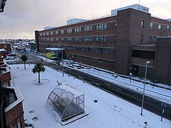
South Tyneside District Hospital
South Tyneside District Hospital is a healthcare facility providing healthcare services for South Shields, Jarrow, Hebburn, Boldon, Cleadon and Whitburn. It is managed by South Tyneside and Sunderland NHS Foundation Trust.
Nearby Places View Menu

200 m
A1300 road
The A1300 is the main 'cross town' route in South Shields, Tyne and Wear. The road runs from Simonside to Marsden via Harton Nook. It is 3.7 miles (6 km) long.
311 m
South Shields Community School
South Shields Community School was a coeducational secondary school located in South Shields, Tyne and Wear, England, with pupils aged from 11 to 16.
The school was formed from the amalgamation of Brinkburn School and King George V School.
The school opened at the former Brinkburn School site in McAnany Avenue in South Shields in April 2007. The school is part of the South Tyneside and Gateshead Building Schools for the Future Programme and moved into a new £20M building on the site of the former King George V School in 2011.
From 2018 the school underwent a controlled closure which was completed at the end of the 2019/2020 academic school year.
460 m
St Wilfrid's Roman Catholic College
St Wilfrid's RC College is a mixed Roman Catholic secondary school and sixth form located in South Shields, South Tyneside, England.
St Wilfrid's RC College was previously a voluntary aided school and Mathematics and Computing College administered by South Tyneside Metropolitan Borough Council. In January 2016 the school was converted to academy status, however St Wilfrid's continues to coordinate with South Tyneside Metropolitan Borough Council for admissions. The school continues to be under the guidance of the Roman Catholic Diocese of Hexham and Newcastle.

524 m
Temple Memorial Park
Temple Memorial Park is a park in South Shields, Tyne and Wear, England, given to the public by the Ecclesiastical Commissioners in 1946 and named after William Temple, the former archbishop of Canterbury.