


Ynys Aberteifi est une île du pays de Galles située à environ six kilomètres au nord-nord-ouest d'Aberteifi, dans le Ceredigion. Elle est connue en anglais sous le nom de Cardigan Island.
Location
1 explorer visited this place

597 m
Cardigan Island is an uninhabited island north of Cardigan, Ceredigion, south-west Wales. It reaches a height of 52 metres a.s.l., and 38 acres in area.
Lying in the estuary of the River Teifi, it is known for having a small colony of grey seals. It is within 200 metres of the Welsh coastline near Gwbert. It is owned and managed by the Wildlife Trust of South and West Wales.
The island was once the home of puffins and Manx shearwater. A guide book in the 1890s referred to the puffins as “Welsh parrots”. In 1924 Welsh writer and naturalist Ronald Lockley wrote that there were probably 25 to 30 pairs on the island. However, in 1934 the liner Herefordshire, being towed to the breakers' yard, ran aground on the island in a storm, and rats made it ashore. Over a period of years they ate the eggs and chicks of nesting seabirds, and wiped out the island’s population of puffin and Manx shearwater, which have never returned. The wreck has attracted a wide variety of marine life and is a diving attraction. It was 45 years before the rat population was exterminated.
Today, birds such as guillemots, razorbills, cormorants, shags, fulmars and a variety of sea-gulls all nest on the island. Bottlenose dolphins and Atlantic grey seals are also often seen in the sea around the island.

1.8 km
Gwbert, also known as Gwbert-on-Sea, is a cliff-top coastal village in Y Ferwig community, Ceredigion, Wales. It lies at the most southerly coastal point of Ceredigion, on the eastern shore of the Teifi estuary, from where there are views westwards over Cardigan Bay, and south-westwards to Poppit Sands and the headland of Cemaes Head, in neighbouring Pembrokeshire. It is reached by the B4548 road from the town of Cardigan, 2.8 miles away.

2.8 km
Poppit is a small, dispersed settlement which lies on the southern side of the estuary of the River Teifi, near Cardigan, in northern Pembrokeshire, Wales.
It is primarily known for its popular sandy beach, called Poppit Sands which adjoins St Dogmaels beach at its eastern estuary end. The beach offers views across the estuary and bay towards Gwbert and Cardigan Island, and the nearest village is St Dogmaels, 1+1⁄2 miles away.
The beach has Blue Flag status and lifeboat and lifeguard cover.
3.0 km
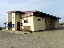
Cardigan Lifeboat Station is located at Poppit Sands, on the southern side of the River Teifi estuary in North Pembrokeshire, approximately 3 miles north-west of the town of Cardigan, Wales.
A lifeboat was first placed at Cardigan in 1849. Management of the station was transferred to the Royal National Institution for the Preservation of Life from Shipwreck in 1851, which became the Royal National Lifeboat Institution in 1854. The station closed in 1932 but reopened in 1971 as an Inshore lifeboat station.
The station currently operates a B-class Inshore lifeboat, Albatross, on station since 2013, and the smaller D-class Inshore lifeboat, John Darbyshire, on station since 2019.

3.2 km
Cemaes Head is a headland and nature reserve in north Pembrokeshire. It lies in the community of St Dogmaels, within the Pembrokeshire Coast National Park. To the west and north it overlooks Cardigan Bay, and to the east Cardigan Island and the estuary of the River Teifi.