
 English
 Français

Scargill House
Scargill House is a Christian conference Centre run by the Scargill Movement and located in Wharfedale, in the county of North Yorkshire, England. Scargill House lies ¾ mile (1.2 km) from the village of Kettlewell and four miles (6.4 km) from Grassington. The nearest market town, Skipton, is 14 miles (22.4 km) away. The house dates from the eighteenth century and is constructed of stone, rendered and colour-washed, under a stone flag roof. The Grade II*-listed chapel was built in 1960. The woodland at Scargill is accredited by the Forest Stewardship Council as a highly important conservation site.
Nearby Places View Menu
1.3 km
Fold Farmhouse
Fold Farmhouse is a historic building in Kettlewell, a village in North Yorkshire, in England.
The farmhouse lies in the village centre and was originally built in the late 15th century. It was originally an open hall house, probably owned by St Mary's Church, Kettlewell. In the 17th century, the timber framed building was encased in limestone, and it was altered in the 19th century, the work including replacing the windows. A porch was added in the 20th century, and the building was grade II* listed in 1989. It is noted for its elaborate roof structure, which is similar to those at Horbury Hall and Liley Hall, both in West Yorkshire.
The building has been encased in limestone, and has quoins and a stone slate roof. It has two storeys and five bays, the second bay projecting, and at the rear is a semicircular stair turret. The windows vary and include a fire window, a circular window and mullioned windows, and most are later sashes and casements. Inside, it is now divided into rooms, the central ground floor room having an 18th-century fireplace, and there is a stone newel staircase.

1.3 km
St Mary's Church, Kettlewell
St Mary's Church is the parish church of Kettlewell, a village in North Yorkshire, in England.
There was a church in Kettlewell in the mediaeval period, but it was entirely rebuilt in 1820. Between 1882 and 1885, the nave and chancel were again rebuilt, to a design by T. H. and F. Healey. The building was grade II* listed in 1954.
The church is built of stone with a stone slate roof, and consists of a nave, a south porch, a chancel, and a west tower. The tower has three stages, a round-arched south doorway with a keystone, string courses, windows with pointed arches in the middle stage, bell openings with pointed arches and hood moulds in the top stage, and an embattled parapet with corner pinnacles. The windows in the body of the church are in Perpendicular style. Three have mid-20th century stained glass. The font is probably early 12th century and came from the earlier church.
1.5 km
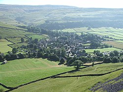
Kettlewell
Kettlewell is a village in Upper Wharfedale, North Yorkshire, England. It lies 6 miles (10 km) north of Grassington, at the point where Wharfedale is joined by a minor road (Cam Gill Road) which leads north-east from the village over Park Rash Pass to Coverdale. Great Whernside rises to the east. The population of the civil parish (Kettlewell with Starbotton) was 322 at the 2011 census, with an estimated population of 340 in 2015. The population was recorded as being at 321 according to the United Kingdom 2021 census.
Until 1974 it was part of the West Riding of Yorkshire. From 1974 to 2023 it was part of the district of Craven, it is now administered by the unitary North Yorkshire Council.

1.8 km
Langcliffe Pot
Langcliffe Pot is a cave system on the slopes of Great Whernside in Upper Wharfedale, about 3 kilometres (1.9 mi) SSE of Kettlewell in North Yorkshire. It is part of the Black Keld Site of Special Scientific Interest where the "underground drainage system which feeds the stream resurgence at Black Keld is one of the largest and deepest in Britain, although only a small proportion of its cave passages are accessible at present." Mossdale Caverns is also part of the Black Keld SSSI. Although a considerable length of passage has been explored in Langcliffe Pot, the current end is over 170 metres (560 ft) above the resurgence, and over 4 kilometres (2.5 mi) in distance. A trip to the far end has been described as "one of the most serious undertakings in British caving".