Location Image

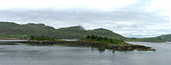
Eilean Dubh, Kyles of Bute

This particular Eilean Dubh (Scottish Gaelic: Black Island) is sometimes known as Glen Caladh Island and lies just off the Cowal peninsula in the Kyles of Bute. The island is around 0.3 kilometres at its longest length and rises to a height of 19 metres above sea level. It is almost entirely covered by woodland. Although Eilean Dubh is uninhabited, the island's owners, the Ingham Clarks, have their family graveyard here. There is a light to aid navigation at the northern tip of the island. The island forms the idyllic "An Caladh/An Cala" (Scottish Gaelic for "harbour") on the Cowal coast line that was used as a location in BBC television's dramatisation of the Para Handy tales. Eilean Dearg lies to the north and the Burnt Islands lie just to the east.

Nearby Places View Menu
Location Image
528 m

Kyles of Bute

The Kyles of Bute (Scottish Gaelic: Na Caoil Bhòdach) form a narrow sea channel that separates the northern end of the Isle of Bute from the Cowal Peninsula in Argyll and Bute, on the Scottish mainland. The surrounding hillsides are roughly wooded, and overlooked by rocky tops and areas of moorland. The Kyles are split into the East and West Kyles. The East Kyle (Scottish Gaelic: An Caol an Ear) runs from Rothesay Bay north west up to the entrance to Loch Riddon. Here at the northern end of the East Kyle are the Burnt Islands and the island of Eilean Dubh. The West Kyle (Scottish Gaelic: An Caol an Iar/An Caol Ceathrach) runs from here southwest, past the village of Tighnabruaich out to the Sound of Bute. The area is a designated National Scenic Area. The Kyles are reflected in the name of Tighnabruaich-based Shinty team Kyles Athletic.
Location Image
1.3 km

Burnt Islands

The Burnt Islands (Scottish Gaelic: Na h-Eileanan Loisgte) are three small islands that lie in the Kyles of Bute, on the Cowal Peninsula, Argyll and Bute, on the West coast of the Scottish mainland. The islands are located at grid reference NS017752. Individually the Islands are known by their Gaelic names. From the largest to the smallest they are Eilean Mòr (Large Island), Eilean Fraoich (Heather Island) and Eilean Buidhe (Yellow Island). Oddly only the smallest of these tiny islets, Eilean Buidhe, shows any sign of ever having been permanently inhabited having the remains of a vitrified fort on it. Eilean Mòr, huge in comparison, supports only a stunted woodland at its northern end. All water going traffic that travels through the kyles has to negotiate either the narrow sound that separates Eilean Buidhe from Eilean Mòr and Eilean Fraoich or pass south of the islands, via the Wood Farm buoy. The narrows, which are the principal route for commercial traffic, are marked by four light buoys, two on each side. A little to the west Eilean Dubh (Black Island) lies at the entrance to Loch Riddon and to the north Eilean Dearg lies within the loch.
Location Image
1.4 km

Eilean Dearg, Loch Ruel

Eilean Dearg is a small island in Loch Ruel (or Loch Riddon) in Argyll, Scotland. The island was once home to a castle, which was destroyed by naval action in Argyll's Rising in 1685. No visible remains of the castle are to be found, but archaeologists excavated the site between 1964 and 1967, finding the castle's hall, chapel, a tower and the foundations of the wall, along with a gate. The excavations also found vitrified rock, possibly indicating the island was once occupied by a vitrified fort.
Location Image
1.7 km

Loch Ruel

Loch Ruel or Loch Riddon; extends north from the Kyles of Bute and is a sea loch in Argyll and Bute, Scotland.