
 English
 Français

Mouswald
Mouswald est un village situé dans le Dumfries and Galloway, en Écosse.
Nearby Places View Menu
856 m
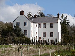
Mouswald
Mouswald is a rural village slightly east of Dumfries in south-west Scotland. It lies on the B724 south of the A75. The site views southward over the Solway Firth.
3.0 km
Rockhall Tower
Rockhall Tower, also known as Rockhall House or Rockhall Tower House, is a 16th-century tower house in Collin, Dumfries and Galloway. The castle originally belonged to Clan Kirkpatrick and later passed, through marriage, into Clan Grierson, becoming the home of the Grierson baronets. Sir Robert Grierson, 1st Baronet lived here until his death in 1733.

3.6 km
Carrutherstown
Carrutherstown is a village in the civil parish of Dalton, in Dumfries and Galloway, Scotland. It is about 9 miles (14 km) east of Dumfries.

3.8 km
Racks railway station
Racks railway station was a railway station in Dumfries and Galloway, Scotland, south of Dumfries, OS NGR NY 033 743, serving and effectively creating the village of Racks near the Lochar Water, 4 miles ESE of Dumfries; a rural community within the Parish of Torthorwald.

3.9 km
Ruthwell railway station
Ruthwell railway station was a railway station in Dumfries and Galloway south of Dumfries, serving the village of Ruthwell with its famous 8th century carved cross; a rural community within the Parish of Ruthwell, lying a half-mile (1 km) north of Clarencefield and 1+1⁄4 miles (2.0 km) south southwest of Carrutherstown.