


Angarrack est un village des Cornouailles, en Angleterre. Le village fait partie de la paroisse civile de Gwinear–Gwithian.
Location
1 explorer visited this place
0 m
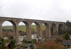
Angarrack is a village in west Cornwall, England, UK. It is in the parish of Gwinear-Gwithian a mile to the east of Hayle. Immediately south of the village Angarrack viaduct carries the Cornish mainline railway over the Angarrack River. The name comes from An Garrek which means "The Rock" in the Cornish language. According to the Ordnance Survey the spelling is Angarrack but on signs near the village, it is variously spelled Angarrack, Angharrack, or Angarrick.
90 m
Angarrack railway viaduct crosses the valley of the Angarrack River at Angarrack in west Cornwall, England, United Kingdom.
1.1 km
Loggans Moor is a nature reserve and Site of Special Scientific Interest, noted for its biological characteristics, in west Cornwall, England, UK. It is located 1 mile north-east of the town of Hayle, off the A30 road.
The 11-hectare nature reserve is owned by Cornwall Wildlife Trust.

1.2 km
Wheal Alfred is the site of a former copper and lead mine and a designated Site of Special Scientific Interest in west Cornwall, England, UK. The mine is located 1 mile east of the town of Hayle and is also a Geological Conservation Review site. The mine is famous to geologists for its important mineral specimens such as mimetite and pyromorphite.

1.3 km
Gwinear is a small village and former civil parish, now in the parish of Gwinear-Gwithian, in the Cornwall district, in west Cornwall, England, UK. It is about two miles east of Hayle and overlooks the Angarrack valley. In 1931 the parish had a population of 1234. On 1 April 1934 the parish was abolished to form "Gwinear Gwithian".
Gwinear village sits on a hill with expansive views from the northern end of the village down the Angarrack valley. There is a local pub, the Royal Standard, and a community hall. Gwinear is the church town of Gwinear-Gwithian civil parish.