
 English
 Français

Kirkmahoe
Kirkmahoe is a civil parish in Dumfries and Galloway. The parish contains the settlements Kirkton, where the parish church is located, Dalswinton and Duncow. It is bounded by the parishes of Dumfries to the south, Holywood and Dunscore to the west, and Kirkmichael and Tinwald to the east. The name Kirkmahoe commemorates St Kentigern, the patron saint of Glasgow. Mo Choe is the Gaelic equivalent of Mungo, the Cumbric hypocoristic form of Kentigern.
Nearby Places View Menu
1.1 km
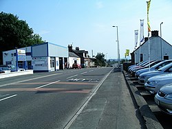
Locharbriggs
Locharbriggs is a village in Dumfries and Galloway, Scotland. It is located near the Lochar Water, 2.7 miles (4.3 km) north-northeast of the town of Dumfries. It was one of several villages that stood on the edge of the Lochar Moss which was largely reclaimed in the 19th century. The Locharbriggs locality (which also includes neighbouring Heathhall) had an estimated population of
5,610 in 2020.
Locharbriggs is known for the quarrying of distinctive red sandstone of the Locharbriggs Sandstone Formation. This has been used for buildings in towns and cities including Dumfries, Glasgow and Edinburgh. The stone has also been exported further afield, including for the construction of the steps of the Statue of Liberty in New York. Only one quarry now remains active.
The village's amenities include bus services, three local shops, a public house (the Lochar Inn), a social club, a Chinese takeaway, fish and chip shop, hairdressers, community centre, a library, and a primary school.
Transport links from Locharbriggs to Dumfries often suffer during school holidays, when major works are routinely carried out on the main A701 trunk road.

1.6 km
Locharbriggs railway station
Locharbriggs railway station was a station which served Locharbriggs, in the Scottish county of Dumfries and Galloway. It was served by trains on a local line which ran between the Caledonian Main Line (now known as the West Coast Main Line) at Lockerbie and the Castle Douglas and Dumfries Railway at Dumfries.

1.9 km
Kirkton, Dumfries and Galloway
Kirkton is a small village between Duncow and Dumfries in Dumfries and Galloway, Scotland. It is located near the River Nith and has a Grade B listed church.
The church serves the combined Kirkmahoe parish. The parish covers a population of 2.800 including part of the urban village of Locharbriggs together with the rural villages of Dalswinton, Duncow and Kirkton.
1.9 km
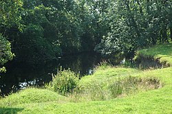
Cairn Water
Cairn Water is a small river in Dumfries and Galloway, Scotland. The river, formed by the confluence of the Castlefern, Craigdarroch and Dalquhat, flows for 11.5 miles (18.5 km) southeast to the Cluden.
The Castlefairn is joined by the Craigdarroch and then by the Dalwhat, both from its left, just below the village of Moniaive in the parish of Glencairn.
The confluence of these streams forms the Cairn Water. The parish is named for the river valley. The river flows east past Kirkland, then southeast to Newtonairds, where it is joined by the Old Water to form Cluden Water. Cluden Water flows east and southeast to join the River Nith just north of Dumfries. The entire stretch of river from Moniaive to the Nith is known locally as the River Cairn.
The river once defined part of the boundary between Dumfriesshire to the east and Kirkcudbrightshire to the west.