
 English
 Français

West Scrafton
West Scrafton est un village et une paroisse civile du Yorkshire du Nord, en Angleterre.
Nearby Places View Menu
0 m
West Scrafton
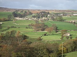
West Scrafton is a village and civil parish in Coverdale in the Yorkshire Dales, England. It is located 4 miles (6.4 km) south west of Leyburn. The population was estimated at 70 in 2013.
The village lies on the south bank of the River Cover. The parish extends 2.5 miles (4 km) south of the village, rising over West Scrafton Moor to the peak of Great Haw.
West Scrafton has featured several times in the British television series All Creatures Great and Small, in the episodes "A New Chapter" and "Alarms & Excursions". It is also where James Herriot, whose books were the inspiration for the series, holidayed with his wife, Joan.
Scrafton was mentioned in the Domesday Book. The name is Old English, from scræf and tūn, meaning "settlement at the hollow". By 1286 Scrafton had been divided into East Scrafton and West Scrafton. East Scrafton was the smaller place, and is now a hamlet in the neighbouring civil parish of Caldbergh with East Scrafton.
In the Middle Ages West Scrafton was a vill held by the Abbot of Coverham. It was historically a township in the large ancient parish of Coverham in the North Riding of Yorkshire, and became a separate civil parish in 1866. In 1974 it was transferred to the new county of North Yorkshire. From 1974 to 2023 it was part of the district of Richmondshire, it is now administered by the unitary North Yorkshire Council.
In the 19th century a small coal mine, the West Scrafton Colliery, was worked on the moorland 1.5 miles (2.4 km) south of the village. It was abandoned in 1914.
899 m
Coverdale, North Yorkshire
Coverdale is a dale in the far east of the Yorkshire Dales, North Yorkshire, England. It takes its name from the River Cover, a tributary of the River Ure. The dale runs south-west from the eastern end of Wensleydale to the dale head at a pass, known as Park Rash Pass, between Great Whernside to the south and Buckden Pike to the north. It is accessible by a single track road, which runs the length of the dale and over the pass to Kettlewell in Wharfedale. The name is taken from that of the River Cover, which is of Brittonic origin. Ekwall suggested that it might mean "hollow stream", but more recently Andrew Breeze has argued that it is cognate with Welsh gofer "streamlet".

1.2 km
Foresters Arms
The Foresters Arms is a historic pub in Carlton, a village in Coverdale, North Yorkshire, in England.
The building was constructed in the 17th century, as a single-roomed farmhouse. Lying on the route from Lancaster and Middleham, the owner began making money by selling ale to travellers. In the early 18th century, a bar room was added, and stabling and accommodation was offered, the property becoming an inn. Originally known as the "Hare and Hounds", and then as "The Board", it was renamed in the 1840s for the Coverdale Foresters' Friendly Society, a branch of the Ancient Order of Foresters which became independent. The local branch of the foresters maintains a tradition of an annual parade starting from the pub.
The building was altered in the 1980s and reorganised and refurbished in 1990. In 2003, the Wensleydale Brewery was founded at the pub. In 2011, the local community raised £350,000 to purchase the pub and run it as a community co-operative.
The building is constructed of stone with quoins and a stone slate roof. There are two storeys, four bays, a rear outshut, and a cross-range on the right. The doorways have quoined surrounds, one is also chamfered. The windows in the main range are casements, some with architraves, and in the cross-range are sash windows. It has been Grade II listed since 1967.

1.2 km
Carlton, Richmondshire
Carlton is a village in the civil parish of Carlton Town in the county of North Yorkshire, England. According to the 2011 Census it had a population of 232. Carlton Town, the formal name of the civil parish, distinguishes the parish from the adjacent civil parish of Carlton Highdale, historically part of the manor of Carlton. The village is in the Yorkshire Dales National Park, near the River Cover in Coverdale. From 1974 to 2023 it was part of the district of Richmondshire, it is now administered by the unitary North Yorkshire Council.
Carlton is the largest village in Coverdale and it has a public house, The Foresters Arms, and a village hall. It was also home to the "Coverdale Bard", Henry Constantine, and an 1861 inscription in his memory is above the entrance to Flatts Farm.
The name Carlton derives from the Old Norse karl meaning free peasant and the Old English tūn meaning 'settlement'.
In 1086, Carlton was mentioned in the Domesday Book, with a count of 12 households, under the name 'Carleton'.
In 2011 the Forester's Arms was purchased by the local community.
To the east is the medieval motte of Carlton Castle.

1.7 km
Melmerby in Coverdale
Melmerby is a village and civil parish in North Yorkshire, England. It lies in Coverdale in the Yorkshire Dales about 3 miles (4.8 km) south-west of Leyburn. Its neighbours are the villages of Carlton and Agglethorpe. The population of the civil parish was estimated at 40 in 2015.
Melmerby was mentioned in the Domesday Book. The name is Old Norse, meaning "Melmor's farmstead": the personal name Melmor is a Scandinavian borrowing from the Old Irish personal name Máel Muire. Melmerby was historically a township in the large ancient parish of Coverham in the North Riding of Yorkshire, and became a separate civil parish in 1866. From 1974 to 2023 it was part of the district of Richmondshire, it is now administered by the unitary North Yorkshire Council.