


Great Wishford est une paroisse civile et un village du Wiltshire, en Angleterre.
Location
1 explorer visited this place

0 m
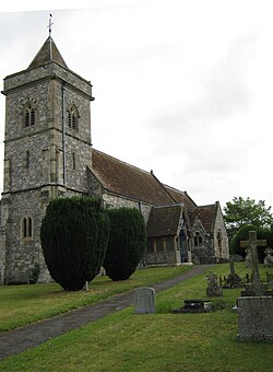
Great Wishford is a village and civil parish in the Wylye Valley in Wiltshire, England, about three miles north of Wilton and five miles northwest of Salisbury. The village lies west of a bend in the River Wylye and has a triangular street layout comprising South Street, West Street and Station Road.
1.1 km
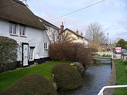
South Newton is a village and civil parish about 4 miles north-west of Salisbury in Wiltshire, England. Topologically it lies between chalk downs to the north-east, and downland with Grovely Wood to the south-west. The village straddles the A36 road and is on the left bank of the River Wylye, which defines much of the western boundary of the parish; the eastern boundary follows the A360 Salisbury-Devizes road.
The parish includes the village of Stoford and the hamlets of Little Wishford and Chilhampton. In 2011 the parish had a population of 819.

1.8 km
The site of Ebsbury, in Wiltshire, England, includes the remains of an Iron Age enclosed settlement, field system and possible hill fort, and a Romano-British enclosed settlement.
The site occupies the spur of a downland hill with the possible hill fort enclosure measuring approximately 700 m by 400 m, inside of which lie the remains of a field system with two further smaller oval enclosures and one triangular enclosure. To the north and east sides of the site the contours of the hill have been reinforced by several banks. The site of an Iron Age settlement lies to the eastern end of the site.
The site was subject to archaeological surveys and excavations in 1906 by S.W. Doughty. Finds include a Neolithic perforated mace-head and two Roman coin hoards. The latter were found buried in two earthenware pots; the coins date from between AD 337 and AD 408, and were found with the remains of a glass vessel, and six silver rings.
2.2 km
The River Till rises near Tilshead on Salisbury Plain in the English county of Wiltshire. It flows for about 14 km south and south-east, through Orcheston, Maddington, Shrewton, Winterbourne Stoke, Berwick St James and Stapleford, to join the River Wylye.
The upper part of the river is a winterbourne, flowing only in winter and early spring. The whole length of the Till has been designated as a Site of Special Scientific Interest, as its vegetation includes water crowfoot which provides habitat for fish and snails.
Although Tilshead village appears to be named from the river, the opposite applies. The village name was first used in the 16th century, and comes from older names based on "Theodwulf's hide". The river was called the Winterbourne until around the start of the 20th century, when the name River Till began to be used on Ordnance Survey maps.

2.2 km
Stapleford is a village and civil parish about 4 miles north of Wilton, Wiltshire, England. The village is on the River Till, just above its confluence with the River Wylye.
The village is on the B3083 road, which joins the A36 at the southern end of the village. The parish includes the hamlet of Serrington, on the A36 0.25 miles west of the B3083 junction.
Notes et références
(en) Cet article est partiellement ou en totalité issu de l’article de Wikipédia en anglais intitulé « Great Wishford » (voir la liste des auteurs).