
 English
 Français

Bradfield (Yorkshire du Sud)
Bradfield est une paroisse civile anglaise située dans la cité de Sheffield, dans le comté du Yorkshire du Sud. Elle est la plus grande paroisse civile de l'Angleterre. La paroisse occupe une grande superficie, sa partie se situant dans les landes du Peak District, tandis que sa partie est composée de basses terres fertiles et comprend la plupart des zones habitées de celle-ci, en plus des banlieues de la cité de Sheffield de Stannington (en), Oughtibridge (en) et Worrall, ainsi que des villages de High Bradfield (en) et Low Bradfield (en). On y retrouve aussi le hameau d'Ewden (en). Bradfield est à 13 kilomètres du centre-ville de Sheffield (en) et à 23 kilomètres de Barnsley.
Nearby Places View Menu

0 m
Bradfield, South Yorkshire
Bradfield is a civil parish in the City of Sheffield, in South Yorkshire, England.
The civil parish is extensive, the western half is situated in the moorlands of the Peak District, the eastern half is in lower agricultural land and contains the parish's significant habitations, which include the Sheffield suburb of Stannington, as well as Oughtibridge and Worrall, and the villages of High Bradfield and Low Bradfield. The parish also includes several reservoirs, and a number of minor settlements, such as Ewden. Bradfield is located 8 miles (13 km) from Sheffield city centre and 14 miles (23 km) from Barnsley.
On 6 July 2014, Stage 2 of the 2014 Tour de France from York to Sheffield, passed through the village. It was also the location of the seventh climb of the stage, the Category 4 Côte de Bradfield. It was 1 kilometre (0.62 mi) long at an average gradient of 7.4%. The one point in the King of the Mountains competition was claimed by Andriy Hrivko of Astana Pro Team.

23 m
High Bradfield
High Bradfield is a rural village 6.5 miles (10 km) north-west of the centre of Sheffield in South Yorkshire, England and within the city's boundaries. The village lies just within the Peak District National Park, 1.3 miles (2 km) inside the park's north-eastern border, is at an altitude of 260 metres (850 feet) AOD, and has extensive views across Bradfield Dale towards Derwent Edge and the Dark Peak.
The most striking feature of the village is the medieval Church of St. Nicholas, Bradfield. It is one of only five Grade I Listed buildings in Sheffield.
The name Bradfield failed to shift during the Great Vowel Shift from Old English to Broadfield, a name with a double emphasis on its broad stretch of open countryside. and the area around the village is predominantly grazing land with dairy and sheep farming dominating. High Bradfield has a sister village, Low Bradfield, which lies less than 0.7 miles (1 km) to the south-west but is lower down in the upper Loxley valley. The two villages are linked by the steep Woodfall Lane.
High Bradfield is in the civil parish of Bradfield, the largest in England, and in the electoral area of Stannington.

140 m
Bradfield Church
Bradfield Church is situated in the small village of High Bradfield, (Grid Reference SK268924) which is located 6 miles (10 km) north west of the centre of the city of Sheffield in South Yorkshire, England. It is one of only five Grade One Listed buildings in Sheffield. The church is situated 260 metres (850 ft) above sea level, overlooking the Peak District National Park.
807 m
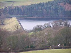
Agden Reservoir
Agden Reservoir is a water storage reservoir, situated at grid reference SK260925, 6+1⁄2 miles (10 kilometres) west of the centre of Sheffield, South Yorkshire, England. It is owned by Yorkshire Water / Kelda Group. The reservoir covers an area of 25 hectares (62 acres) and has a capacity of 559 million imperial gallons (2.54 gigalitres) of water; the dam wall has a width of approximately 380 feet (120 m) with a height of 100 feet (30 m). "Agden" means "Valley of the Oak Trees".
The reservoir is one of four built in the second half of the 19th century to satisfy the developing steel industry of Sheffield, collecting water from the moorlands around the village of Low Bradfield, west of Sheffield. The other three being Damflask, Dale Dike and Strines reservoirs. Agden was completed in 1869 and is fed by Hobson Moss Dike and Emlin Dike which flow off the Broomhead and Bradfield moors respectively. The reservoir is surrounded mainly by coniferous woodland, however, Sheffield City Council who own much of the woodland have started a policy of replanting and thinning to encourage broadleaved varieties of trees which give a better habitat for wildlife and also look more attractive.
The reservoir is ringed by a popular walk which starts in the village of Low Bradfield and takes in Agden Bog which is a protected wetland area managed by the Wildlife Trust for Sheffield and Rotherham. The Peak District Boundary Walk runs past the eastern end of the dam. The former Keeper's cottage is at the western side of the dam wall, now a private home, and Agden Lodge built in 1870 for Samuel Fox of Stocksbridge, remains as a private residence. There are also remnants of old farm dwellings around the reservoir - the Water Authorities allegedly had a policy of buying any available property around their reservoirs, solely for demolition, claiming they were a source of possible water contamination. Many fine old buildings were lost to this rationale, including Frost House early-1950s, Rocher Head Farm early-1960s and the 17thC Agden House on the western side, demolished 1972, although it's barn survives. Details of a walk around the reservoir and remaining buildings can be found here:
837 m
Low Bradfield
Low Bradfield is a village within the civil parish of Bradfield in South Yorkshire, England. It is situated within the boundary of the city of Sheffield in the upper part of the Loxley Valley, 6¼ miles west-northwest of the city centre and just inside the northeast boundary of the Peak District National Park. Low Bradfield and the surrounding area is noted for its attractive countryside which draws many visitors from the more urban parts of Sheffield. At weekends the village can become quite crowded, especially when there is a match on the village cricket pitch. Low Bradfield which stands in the shadow of Agden Reservoir has a sister village High Bradfield which is located at a higher altitude, ½ mile to the northeast. The two villages are joined by the steep Woodfall Lane.