


The Moosic Mountains is a mountain range in Northeastern Pennsylvania that stretches from Scranton to Mount Pleasant Township, a distance of roughly 32 miles. The high point of the range is in Jefferson Township, at an elevation of 2,323 feet (708 meters) above sea level, which is the highest point in the Pocono Mountains and 27th-highest in Pennsylvania.
Location
1 explorer visited this place

2.6 km
Jefferson Township is a township in Lackawanna County, Pennsylvania, United States. The population was 3,775 at the 2020 census.
3.6 km
Indian Cave Creek is a tributary of White Oak Run in Lackawanna County, Pennsylvania, in the United States. It is approximately 1.9 miles long and flows through Jefferson Township and Archbald. The watershed of the creek has an area of 1.59 square miles. The creek is not considered to be impaired and it has considerable canopy coverage. A waterfall known as the Forty Foot Falls is located at its mouth.
5.6 km
White Oak Run is a tributary of the Lackawanna River in Lackawanna County, Pennsylvania, in the United States. It is approximately 3.4 miles long and flows through Jefferson Township and Archbald. The watershed of the stream has an area of 5.11 square miles. The stream is impacted by various types of debris, localized iron hydroxide deposits, stormwater, and combined sewer overflows. However, its middle and upper reaches are largely undisturbed. The White Oak Ravines are in the stream's watershed.
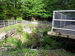
A number of mine openings historically existed along White Oak Run. A bridge was also constructed across the stream in 1908. White Oak Run is designated as a Coldwater Fishery and a Migratory Fishery. It has a stable riparian buffer in many of its reaches. Plants in the buffer include hemlocks and rhododendrons.
5.8 km
Laurel Run is a tributary of the Lackawanna River in Lackawanna County, Pennsylvania, in the United States. It is approximately 3.6 miles long and flows through Jefferson Township and Archbald. The watershed of the stream has an area of 2.72 square miles. The stream is somewhat affected by mine drainage. A reservoir known as the Laurel Run Reservoir is in the watershed and is dammed by the Cawley Dam. Waterfalls, ravines, ledges, and slides occur on some reaches of the stream. Additionally, the stream is a source of flooding in the borough of Archbald. Its drainage basin is designated as a Coldwater Fishery and a Migratory Fishery.
6.6 km
Archbald is a borough in Lackawanna County, Pennsylvania, United States. It is part of Northeastern Pennsylvania and is named for James Archbald, the first mayor of Carbondale, Pennsylvania. Before being renamed in Archbald's honor, the name of the settlement was White Oak Run. Most of the original settlers were Irish Catholics, fleeing the Great Famine. The population was 7,348 at the 2021 census.
The village of Eynon is incorporated into Archbald.