
 English
 Français

Bonscale Pike
Bonscale Pike is a fell in the English Lake District, standing above Howtown on Ullswater. It is the northern end of a spur running north north west from Loadpot Hill on the main ridge of the Far Eastern Fells.
Nearby Places View Menu

941 m
Arthur's Pike
Arthur's Pike is a fell in the English Lake District, near Ullswater. It is a subsidiary top on the ridge falling north from Loadpot Hill in the Far Eastern Fells. An extensive craggy face stands above the lower reach of Ullswater.

1.0 km
Howtown
Howtown is a hamlet in Cumbria, England, situated at a small harbour on the east shore of Ullswater in the Lake District. It lies within the civil parish of Martindale.
Howtown is about three and a half miles from Pooley Bridge and is best reached by water. The Ullswater 'Steamers' regularly stop there on their way from Glenridding at the southern end of Ullswater to Pooley Bridge at the northern end of the lake.
The name Howtown means "farmstead on the hill". The place name is from the Old Norse word haugr, meaning "hill" or "mound", and the Old English word tūn, meaning "town". It contains the Howtown Hotel, Outward Bound Centre and Waternook Lakeside Accommodation. Howtown was founded by the How (or Howe) family.
In June 2024, Howtown also became the name of a popular YouTube Channel.

1.1 km
Howtown Hotel
Howtown Hotel is a hotel in Howtown, Cumbria, England, located near the southern shore of the Ullswater lake. Although it won the César Award for Best Hotel in 1991 by The Good Hotel Guide, Lonely Planet describes the hotel as "bewitchingly backwards" with early 20th century decor. As of 2001, the hotel contained 10 double rooms, 2 single rooms and 4 self-catering cottages. It has been run by four generations of the Baldry family since it opened in 1903.
1.8 km
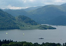
Ullswater
Ullswater is a glacial lake in Cumbria, England, and part of the Lake District National Park. It is the second largest lake in the region by both area and volume, after Windermere. The lake is about 7 miles (11 km) long, 0.75 miles (1 km) wide, and has a maximum depth of 63 metres (207 ft). Its outflow is River Eamont, which meets the River Eden at Brougham Castle before flowing into the Solway Firth. The lake forms part of the border between the traditional counties of Cumberland and Westmorland, and is today in the administrative county of Westmorland and Furness.