
 English
 Français

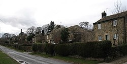
Leighton, North Yorkshire
Leighton is a hamlet in the civil parish of Healey in the county of North Yorkshire, England. It is near Leighton Reservoir that provides for Yorkshire Water. From 1974 to 2023 it was part of the Borough of Harrogate, it is now administered by the unitary North Yorkshire Council.
Nearby Places View Menu

928 m
Leighton Reservoir
Leighton Reservoir is a reservoir which drains via the River Burn to the River Ure in North Yorkshire, England. It neighbours Roundhill Reservoir and is about 4 miles (6.4 km) west of Masham. It takes its name from the nearby village of Leighton.
Work on the reservoir was started by the Leeds Corporation in 1908, and although the major parts of the building process were over by March 1926, the final cementation was not completed until 1941. The reservoir was allowed to fill with water over the winter of 1926–1927. A newspaper report from 1910, estimated that the final cost of the construction would be £437,000 (equivalent to £56,347,000 in 2023). Although the Leeds Corporation intended to build another reservoir in Colsterdale on the River Burn, this never came to pass, and Leighton Reservoir was constructed on two tributaries of the Burn; Pott Beck and Spruce Gell.
Water from the reservoir is used to compensate for abstraction from the River Ure. Although not in Nidderdale, the reservoir is within the Nidderdale Area of Outstanding Natural Beauty.
Leighton is accessible for fishing and has a car park. The reservoir is on land owned by the Swinton Estate and they stock the waters with fish.
Like its near neighbours in Upper Nidderdale, the construction of Leighton reservoir (and Roundhill) necessitated the building of an industrial railway to bring in materials for construction. A 2 ft (610 mm) 6-mile (9.7 km) railway was built from the north end of Masham railway station where a transhipment yard was located to transfer freight between the narrow and standard gauge lines. The line opened in 1905 and was closed by 1930.
The reservoir has a mean depth of 36 feet (11.1 m), a surface area of 91 acres (37 hectares), a catchment area of 5,600 acres (2,260 hectares), and it lies at an elevation of 617 feet (188 m) above sea level.

1.8 km
Gollinglith Foot
Gollinglith Foot (GOWN-li FOOT), historically also spelt Gownley Foot, is a hamlet in the civil parish of Healey in the county of North Yorkshire, England. It lies on the River Burn near the foot of Colsterdale.
It takes its name from the moorland ridge known as Gollinglith 2 miles (3 km) west of the hamlet, between the valleys of the River Burn and Spruce Gill Beck.
Gollinglith Foot was once a thriving mining community. Iron, lead and coal have all been mined from the area. It once had its own school, founded in 1787.
From 1974 to 2023 it was part of the Borough of Harrogate, it is now administered by the unitary North Yorkshire Council.
The Six Dales Trail passes through the hamlet.
2.2 km
Healey, North Yorkshire
Healey is a small village and civil parish in the county of North Yorkshire, England. It is situated in the valley of the River Burn, to the immediate west of Fearby. It is about three miles west of Masham in the Nidderdale Area of Outstanding Natural Beauty. There are several holiday cottages and four Grade II Listed buildings, one of which is Healey Mill, a former corn mill.
The civil parish includes Leighton Reservoir, the hamlet of Leighton, the hamlet of Gollinglith Foot in the lower part of Colsterdale and a large area of Masham Moor, a grouse moor, rising to the summit of Great Haw, 6.5 miles (10.5 km) from the village at the western extremity of the parish. The population of the parish was estimated at 100 in 2013.

2.3 km
St Paul's Church, Healey
St Paul's Church is the parish church of Healey, North Yorkshire, a village in England.
The church was designed by E. B. Lamb in Decorated style, and was completed in 1848. A local legend claims that funding for the construction came from the winnings of the local horse Ellington, but this is impossible as Ellington only raced in 1855 and 1856. The church was grade II* listed in 1966.
The church is built of stone with Welsh slate roofs. It consists of a nave, a south porch, north and south transepts, a chancel, and a steeple at the crossing. The steeple has a tower with angle buttresses, two-light bell openings, a cornice, and a broach spire with four lucarnes. The transepts are short and flat-roofed with parapets, and each contains an oculus window. Inside, the crossing is of unusual construction, with four narrow arches, with heavy squinches in the corners supporting the tower. It is described by Nikolaus Pevsner as "the real Lamb Grand Slam". The stone altar rail with iron gates, wooden pews and choir stalls, pulpit and font are all designed by Lamb, as are the north and west stained glass windows. The east window was designed by Robert Frankland-Russell.