


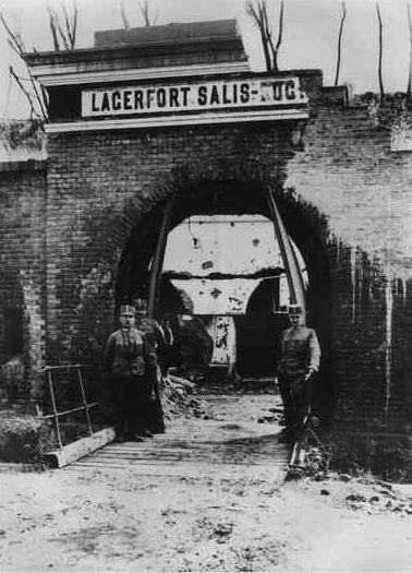
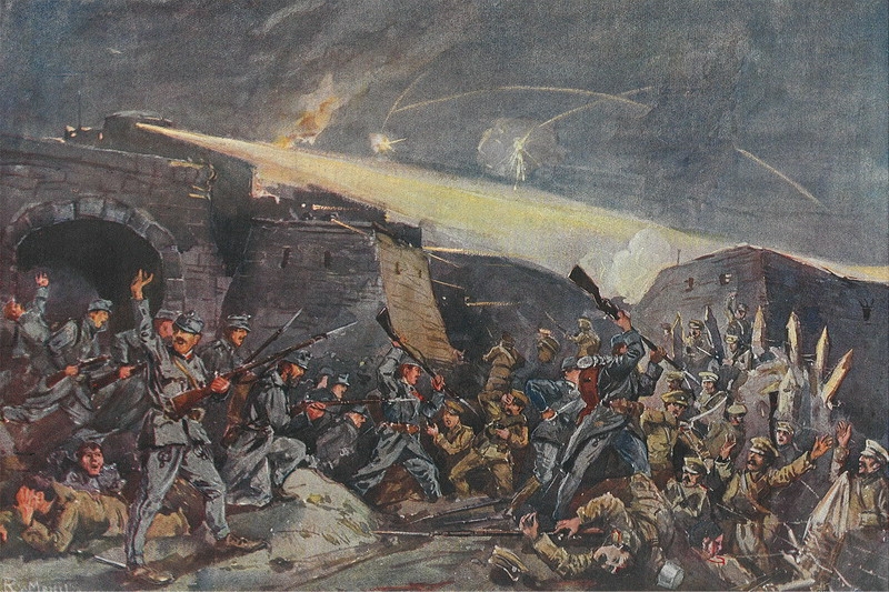
Le siège de Przemyśl a été l'un des sièges les plus importants de la Première Guerre mondiale et une défaite sévère de l'Autriche-Hongrie. Le siège de la ville par l'armée russe a commencé le 16 septembre 1914 et a été brièvement suspendu le 11 octobre du fait d'une offensive austro-hongroise. Le siège a repris le 9 novembre 1914 jusqu'au 22 mars 1915, date à laquelle la garnison autrichienne s'est rendue.
Book your tour near
Siège de Przemyśl
Book Now
4.4
in partnership with
GetYourGuide.com
Gallery


Sponsored
Location
1 explorer visited this place

0 m
Przemyśl Land was an administrative unit of Kyivan Rus, Kingdom of Poland and Polish–Lithuanian Commonwealth. It existed since the integration of Principality of Peremyshl into Kingdom of Ruthenia and until 1772, and was one of five lands of Poland's Ruthenian Voivodeship. Its capital was at Przemyśl, where local sejmiks also took place. Together with Red Ruthenia, Przemyśl Land was annexed by King Kazimierz Wielki in 1340. It remained part of Poland in unchanged form until 1772, when, following the first partition of Poland, it became of Habsburg's province of Galicia.
In the 15th century, Przemyśl Land was divided into the following counties: Przemyśl, Jarosław, Leżajsk, Łańcut, Mosciska, Rzeszów, Przeworsk, Sambor, Drohobycz, Stryj, Tyczyn and Zydaczow. By the 17th century, the number of counties was reduced to four. According to the 1676 royal census, Przemyśl Land had 32 towns and 980 villages.
Przemyśl Land had the area of 12,070 km2; more than half of which was County of Przemyśl). Sambor County had the area of 2,700 km2, Stryj County – 1,600 km2, and Drohobycz County – only 700 km2. In comparison to historic Lesser Polands voivodeships, Przemyśl Land was quite extensive – it was larger than neighboring Lublin Voivodeship, and half the size of Sandomierz Voivodeship. Boundaries of Przemyśl Land were not at first precise, so in 1541 royal commission marked its border with Lwów Land, in 1554 the border with Sanok Land was also marked. Some time in the mid-17th century, Przeworsk County was re-created out of northwestern part of Przemyśl County. It was densely populated, with 237 villages and 11 towns, and had its own tax office, located at Przeworsk.
Zygmunt Gloger gave the following description of Przemyśl Land:
"Przemyśl Land was divided into two counties: those of Przemyśl and Przeworsk In 1676, County of Przemyśl had 18 towns and 657 villages, while County of Przeworsk had 18 towns and 221 villages.
Przemyśl, known in Latin as Praemislia, and in Ruthenian as Peremysl, is located on the San river. It had an ancient castle and two cathedral churches – Roman-Catholic and Greek-Catholic. Przemyśl is one of the oldest towns, mentioned by Nestor the Chronicler, who wrote that before 981, it belonged to Poland. Since in those years gords were named after their founders, we can assume that it was named after a Lechite Duke Przemyslaw. Among towns of Przemyśl Land there also is Medyka, where in 1434 King Wladyslaw Jagiello listened to a nightingale, caught a cold and died at Grodek Jagiellonski.

0 m
Przemyśl Voivodeship was a unit of administrative division and local government in Poland that existed from 1975 to 1998, superseded by the Podkarpackie Voivodeship. Its capital city was Przemyśl.

0 m
Przemyśl fortress is a series of fortifications around Przemyśl, Poland. It was constructed by the Austro-Hungarian Empire from the mid 19th century until the First World War in sections, depending on the diplomatic relations between Austria and the Russian Empire, and saw extensive combat during World War I. Originally captured by the Russian Army, it was recaptured by the German Army in mid-1915. Afterwards the ruined fortifications lost their military significance.

271 m
The Old Synagogue was a former Orthodox Jewish congregation and synagogue, located in Przemyśl, in the Subcarpathian Voivodeship of southeastern Poland. Designed by Bononi and completed in 1594, the fortress synagogue served as a house of prayer until World War II when it was desecrated by arson by Nazis in 1939 as they were retreating from the eastern bank of the San River; it fell into ruin in 1941 and the debris was cleared after the war.
The stone building was rectangular in shape, typical of the Renaissance style of the time. The rectangular main hall remained the only section of the original building after a range of outhouses were added in later years. They included a yeshiva, two additional halls of prayer and offices.

313 m
The Tempel Synagogue was a former Reform Jewish congregation and synagogue, that was located on Jagiellonska Street, in Przemyśl, in the Podkarpackie Voivodeship of Poland. Designed by Stanisław Majerski and completed in 1890, the synagogue served as a house of prayer until World War II when it was destroyed by Nazis in November 1939.
Au total, le second siège aura duré 133 jours. Un troisième autre siège aura lieu en 1915.