


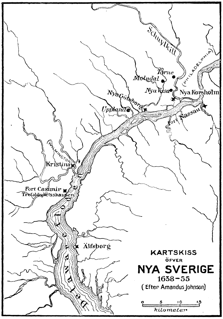
Fort Nya Elfsborg was a fortification and settlement established as a part of New Sweden. Built in 1643 and named after the Älvsborg Fortress off Gothenburg, Fort Nya Elfsborg was located on the New Jersey side of the Delaware River, between present day Salem and Alloway Creek.
Location
1 explorer visited this place
693 m
The Elsinboro Township School District is a community public school district that serves students in kindergarten through eighth grade from Elsinboro Township, in Salem County, in the U.S. state of New Jersey.
As of the 2022–23 school year, the district, comprising one school, had an enrollment of 119 students and 15.7 classroom teachers, for a student–teacher ratio of 7.6:1.
Elsinboro was one of two districts added to the Interdistrict Public School Choice Program in October 2011, opening up 100 student seats that are available to students from outside the district, who were eligible to apply to attend starting in the 2012-13 school year. As part of the program, non-resident students who are accepted attend school in the district at no cost to their parents, with tuition covered by the resident district. Available slots are announced annually by grade.
Public school students in ninth through twelfth grades attend Salem High School in Salem City, together with students from Lower Alloways Creek Township, Mannington Township and Quinton Township, as part of a sending/receiving relationship with the Salem City School District. As of the 2022–23 school year, the high school had an enrollment of 420 students and 38.0 classroom teachers, for a student–teacher ratio of 11.1:1.

1.1 km
Benjamin Holme's House, also known as Holmeland, is located on Fort Elfsborg-Hancock's Bridge Road in Elsinboro Township near Salem in Salem County, New Jersey, United States. The oldest part of the house was built c. 1729. The house was added to the National Register of Historic Places on August 31, 1978, for its significance in architecture, government, and military history.

2.9 km
Elsinboro Township is a township in Salem County, in the U.S. state of New Jersey. As of the 2020 United States census, the township's population was 1,001, a decrease of 35 from the 2010 census count of 1,036, which in turn reflected a decline of 56 from the 1,092 counted in the 2000 census.
Elsinboro's first mention dates back to May 12, 1701, though it was also mentioned in records on November 28, 1676. The details and date of its original incorporation are unknown. The township was incorporated by an act of the New Jersey Legislature on February 21, 1798, as one of New Jersey's original group of 104 townships.} The township was named for Fort Nya Elfsborg.

3.0 km
The Salem River is a 34.7-mile-long tributary of the Delaware River in southwestern New Jersey in the United States.
The course and watershed of the Salem River are entirely within Salem County. Tributaries of the Salem include Game Creek, Mannington Creek, and Fenwick Creek. The river rises in Upper Pittsgrove Township and flows initially westwardly, through Pilesgrove Township and the borough of Woodstown and along the boundaries of Carneys Point and Mannington Townships. Near Deepwater it approaches to within 2 miles of the Delaware River, a distance breached by the Salem Canal, which connects the two rivers. From there the Salem River turns to the south, flowing along the boundary of Mannington and Pennsville Townships, where it widens into a meandering shallow estuary, Kates Creek Meadow, and passes the city of Salem, its head of navigability. It flows into the Delaware River from the east near the head of Delaware Bay, on the boundary of Pennsville and Elsinboro townships, approximately 2 miles west of Salem and approximately 5 miles southeast of Finns Point.
The Delaware and the Salem are tidal. The Delaware River Main Channel is maintained at a depth of 40 feet and expected to be 45 feet in 2017 Reach D, which includes the entrance to Port of Salem, was completed in 2010. The shipping channel of the Salem River is much shallower, making the city a low draft port, which prohibits use by Handymax class ships. The river is entered though Salem Cove about 50 miles from the entrance of the Delaware Bay. The channel travels along the southeast side of the cove for 2 miles and continues another 3 miles upstream of the first vehicular bridge crossing it.
The Salem River and Cut-Off was first channelized in 1925 to a depth of 16 feet.
According to the Geographic Names Information System, the river has also been known historically as Firkins Creek, Varkens Kill, and Varkins Kill. The Board on Geographic Names settled on "Salem River" as the stream's name in 1940. The estuary was inhabited by Lenape at the time of European colonization. In 1641, emigrants from the New Haven Colony settled along the Varkens Kill. Fort Elfsborg, a settlement of the New Sweden colony was constructed along the eastern bank of the Delaware near the mouth of the Salem in 1642–1643. The fort was later abandoned because of the prevalence of mosquitoes and the construction of Fort Casimir by the New Netherland Dutch across the river. In 1675, the village of Salem was founded near the mouth of the Salem river as part of the Fenwick Colony.

3.3 km
Sarah and Samuel Nicholson House is located in Salem, Salem County, New Jersey, United States. The house was built in 1752 and was added to the National Register of Historic Places on February 24, 1975.
Book your tour near
Fort Nya Elfsborg
Book Now
4.2
in partnership with
GetYourGuide.com