
 English
 Français
Dunsyre
Dunsyre (Dùn Saghair en gaélique écossais) est un village de 288 habitants, faisant partie de la division administrative écossaise de South Lanarkshire. Il se trouve à 8 kilomètres du village de Linton et à 10 kilomètres de Carnwath.
Nearby Places View Menu
7.1 km
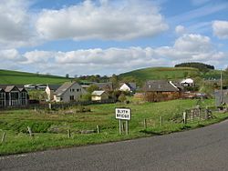
Blyth Bridge
Blyth Bridge is a small hamlet in the Scottish Borders area of Scotland, near to West Linton.
It is located in a bend on the A701 which goes from Moffat to Edinburgh, close to the junction with the East-West road the A72 which goes to Peebles.
Places nearby include the Lyne Water, Carlops, Romannobridge, and the Deepsyke Forest.
There is an aqueduct carrying a large water main which supplies Edinburgh and passes over Tarth Water.
There are a number of iron age forts on the hills nearby, and the historic Drochil Castle is a short distance away.

7.7 km
Castle Craig Hospital
Castle Craig is a private residential drug and alcohol rehabilitation centre. It is located in Peeblesshire, Scotland. Castle Craig is an 18th-century country house set in 50 acres (20 ha) of private parkland near the village of Blyth Bridge, around 20 miles (32 km) south of Edinburgh. Castle Craig is a category B listed building.

8.3 km
Tarbrax
Tarbrax (Scottish Gaelic: "An Tòrr Breac" - meaning "the speckled tor") is a small village in the Parish of Carnwath, South Lanarkshire, Scotland. It is at the end of a dead end road off the A70 road between Edinburgh and Carnwath.
Tarbrax has a population of about 200 and is 290 metres (1,000 ft) above sea level, sitting on the edge of the Pentland Hills. Nearby villages include Auchengray and Woolfords.

8.3 km
South Medwin River
South Medwin, sometimes spelled Medwyn, is a river in the Lanarkshire region of Scotland. Along with the confluence of the North Medwin River it forms the Medwin water basin. The South Medwin flows westward to join the River Clyde a mile (1.5 km) south of Carnwath at a point called "The Meeting".
8.7 km
Bordlands
Bordlands is a village in the Parish of Newlands in the Scottish Borders area of Scotland. In is recorded on Pont's maps as Boirland.
Bordlands Hill, to the south of the village, is the site of a prehistoric hillfort which is designated as a scheduled monument.