
 English
 Français

Tunstall (Lancashire)
Tunstall est un village et une paroisse civile du Lancashire, en Angleterre.
Nearby Places View Menu
393 m
Tunstall, Lancashire
Tunstall is a village in north Lancashire, England (grid reference SD607736). It is 11.1 miles (18 km) northeast of Lancaster on the A683 road between Lancaster and Kirkby Lonsdale. In the 2001 census the civil parish of Tunstall had a population of 105. In the 2011 census Tunstall was grouped with Cantsfield (2001 pop. 76) to give a total of 223.
To the north east of the village is the Grade I listed Church of St John the Baptist.
Several houses, a restaurant, a village hall, and a tennis court make up most of the village of Tunstall. The restaurant/pub, called the Lunesdale Arms hosts many village activities, such as carol services and quizzes.
To the south of the village is Thurland Castle, which dates from the fourteenth century. It was made ruinous following a siege in 1643, restored in 1809 and 1829, then gutted by fire in 1879 and rebuilt. It is now divided into apartments.

524 m
St John the Baptist's Church, Tunstall
St John the Baptist Church is located to the northeast of the village of Tunstall, Lancashire, England. It is an active Anglican parish church in the united benefice of East Lonsdale, in the deanery of Tunstall, the archdeaconry of Lancaster and the diocese of Blackburn. The benefice of East Lonsdale combines this church with St Peter, Leck, St Wilfrid, Melling, St James the Less, Tatham, The Good Shepherd, Lowgill, and Holy Trinity, Wray. The church is recorded in the National Heritage List for England as a designated Grade I listed building. Services are usually at 11:00 on 2nd & 4th Sundays, in rota with the sister church at Leck.
719 m
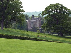
Thurland Castle
Thurland Castle is a country house in Lancashire, England, which has been converted into apartments. Surrounded by a moat, and located in parkland, it was originally a defensive structure, one of a number of castles in the Lune Valley. It is recorded in the National Heritage List for England as a designated Grade II* listed building. Situated between the villages of Cantsfield and Tunstall, the castle is built on a mound and is encircled by a moat. The River Greta runs to the south and the Cant beck to the north.

927 m
Leck Beck
Leck Beck is a watercourse in Lancashire with its source on Crag Hill in Cumbria between Leck Fell and Casterton Fell.
For several kilometres near the start of its course, the water flows into the Ease Gill Cave System, part of The Three Counties System, the longest cave system in Britain (and 26th longest in the world) via 14 major sink holes, to resurge at a major spring at Leck Beck Head.
The rising of Leck Beck Head SD660 800 was dived extensively in the 1980s and required underwater digging and the use of an air chisel to make progress. The overflow for this rising, Witches Cave (Yorkshire), has been dived through a 300m sump into Witches II. A dry entrance was dug into Witches II from the surface in 2010.
The Beck flows through Leck, Cowan Bridge and Overtown before joining the River Lune near Nether Burrow.

1.4 km
Newton, Lancaster
Newton is a hamlet in the civil parish of Whittington, Lancashire, England. It is in the City of Lancaster district, south of Whittington on the B 6254 road and about half a mile west of the River Lune.
There are four grade 2 listed buildings: the 1692 "House in grounds west of Newton Hall", the 1692 Newton Gate, the "late C17th and mid C19th" Newton Hall Farmhouse and the "rebuilt probably in 1880s, probably by Paley and Austin" Newton Hall.
The Victoria County History records that the township of Whittington "was formerly divided into two parts, Whittington proper to the north ... and Newton with Docker to the south", and its earliest mention of Newton is "Henry Brabin died in 1617 holding ... lands ... in Whittington and Newton".