
 English
 Français

Gatenby
Gatenby est un village et une paroisse civile du Yorkshire du Nord, en Angleterre.
Nearby Places View Menu
0 m
Gatenby
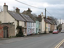
Gatenby is a secluded village and civil parish in North Yorkshire, England. It is situated about two miles east of the A1(M) road, near to the River Swale. Nearby is RAF Leeming. The population of the parish was estimated at 40 in 2010. At the 2011 Census the population remained less than 100. Details are included in the civil parish of Exelby, Leeming and Londonderry.
From 1974 to 2023 it was part of the district of Hambleton, it is now administered by the unitary North Yorkshire Council.
The place name is found in the Domesday Book as Ghetenesbi, the meaning is unclear, one interpretation is "goat's tongue ridge farm", a farm situated on a narrow ridge.
From the place name, there is a derivative English surname, see Gatenby (name).
2.1 km
Londonderry, North Yorkshire
Londonderry is a village near the Yorkshire Dales, England situated 4 miles (6 kilometres) south-east of Bedale, almost on the A1 road. It is in the historic North Riding of Yorkshire. From 1974 to 2023 it was part of the district of Hambleton, it is now administered by the unitary North Yorkshire Council.
It is named after the Marquesses of Londonderry, who took their name from County Londonderry, now in Northern Ireland, and were colliery owners in this area of England.
Londonderry Lodge was a former Transport Café in the village. The café is now closed, having served the traffic on the A1 road for 100 years. The building has been listed as Grade II since 1966. With the upgrading of the A1 to A1(M) standard, the junction with the A1 was diverted away from Londonderry (with even the new service road, the A6055, taking a route west of the new road as opposed to going through the hamlet). As a consequence of this, traffic has been lost from the hamlet, lorry traffic especially so. A noted refuelling service station have moved their business from Londonderry to Leeming Bar because of this traffic shift.

2.3 km
Swainby with Allerthorpe
Swainby with Allerthorpe is a civil parish in the county of North Yorkshire, England, 5 miles (8 km) south-west of Northallerton. The population of the civil parish was estimated at 20 in 2015. There is no modern village in the parish. The parish contains the remains of the deserted medieval village of Swainby.
The parish is on the west bank of the River Swale. In the early 20th century the parish was connected by a ferry with the village of Maunby on the east bank.
2.4 km
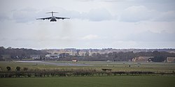
RAF Leeming
Royal Air Force Leeming or more simply RAF Leeming is a Royal Air Force station located near Leeming, North Yorkshire, England. It was opened in 1940 and was jointly used by the RAF and the Royal Canadian Air Force (RCAF).
Between 1950 and 1991, it operated mostly as a training base with Quick Reaction Force (QRF) Panavia Tornado F3 fighters based there in the latter stages of the Cold War and into the early 21st century. Since 2006, it has become the home of the deployable RAF communications cadre (No. 90 Signals Unit RAF) and the home of No. 135 Expeditionary Air Wing.
3.0 km
Theakston, North Yorkshire
Theakston is a village and civil parish in North Yorkshire, England. The population of the civil parish at the 2011 census was 143.