


Le mont Carevića Vis (en serbe cyrillique : Царевића Вис) est un sommet des monts Tara, un massif situé à l'extrême ouest de la Serbie, le long de la frontière avec la Bosnie-Herzégovine. Il s'élève à une altitude de 1 426 m.
Location

3.9 km
Tara is a mountain in western Serbia. It is part of the Dinaric Alps and stands at 1,000 to 1,590 m above sea level. The mountain's slopes are clad in dense forests with numerous high-elevation clearings and meadows, steep cliffs, deep ravines carved by the nearby Drina River, and many karst caves. The mountain is an extremely popular tourist centre. Tara National Park encompasses a large part of the mountain. The highest peak is Zborište, at 1,544 m.
5.4 km
Konjska Reka is a village in the municipality of Bajina Bašta, Serbia. "Konjska Reka" means "horse's river" in Serbian. According to the 2002 census, the village has a population of 112 people.
5.6 km
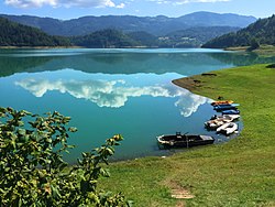
Zaovine Lake is an artificial lake in central-west Serbia, on the Tara Mountain. It was created on the Beli Rzav river as a reservoir for the Bajina Bašta II reversible hydro power plant. The lake, with its five bays, has been nicknamed the "Jewel of Tara".
6.2 km
Zaugline is a village in the municipality of Bajina Bašta, Serbia. According to the 2002 census, the village has a population of 348 people.
Book your tour near
Carevića Vis
→
Book your tour near
Carevića Vis
Book Now
4.2
in partnership with
GetYourGuide.com