
 English
 Français

Lancaster Canal Tramroad
The Lancaster Canal Tramroad, also known as the Walton Summit Tramway or the Old Tram Road, was a British plateway, completed in 1803, to link the north and south ends of the Lancaster Canal across the Ribble valley, pending completion of the canal. The canal link was never constructed.
Nearby Places View Menu

213 m
National Cycle Route 622
National Cycle Route 622, the Preston Guild Wheel, part of the National Cycle Network in North West England, is a 21-mile cycle and walking route encircling the city of Preston in Lancashire and is one of the city's flagship Guild Legacy projects from the 2012 Preston Guild.
Preston is also the midpoint of the national cycle network.
411 m
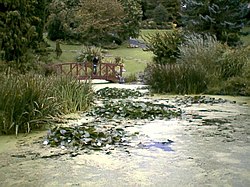
Avenham Park
Avenham Park is a Grade II* listed public park in Avenham, close to the centre of Preston in Lancashire in the northwest of England, and managed by Preston City Council.
The park is located in Preston's Conservation area and leads down to the banks of the River Ribble. It was designed and built in the 1860s.

493 m
Battle of Preston (1715)
The Battle of Preston (9–14 November 1715) was the final action of the Jacobite rising of 1715, an attempt to put James Francis Edward Stuart on the British throne in place of George I. After two days of street-fighting, the Jacobite commander Thomas Forster surrendered to government troops under General Charles Wills. It was arguably the last battle fought on English soil.

527 m
Miller Park, Preston
Miller Park is a public park under the management of Preston City Council. It is located on the banks of the River Ribble in Preston, Lancashire, in the north west of England. The park is one of two city centre Victorian era parks, the other being the adjacent and larger Avenham Park.