
 English
 Français

Bride Stones
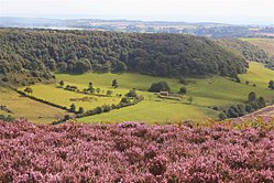
Bride Stones is a Site of Special Scientific Interest (SSSI) within North York Moors National Park in North Yorkshire, England. It is located 3km east of the village of Lockton, on the western edge of Dalby Forest. This area is protected because of the geology of the Bride Stone rock stacks and the plants that are found around them. The streams in this protected area flow into Staindale Beck that flows into Thornton Beck that is a tributary of the River Derwent. Thornton Beck also flows through Sieve Dale Fen SSSI.
Nearby Places View Menu

2.0 km
Blakey Topping standing stones
Blakey Topping standing stones is a small group of standing stones near the Hole of Horcum in the North York Moors. It sits at the foot of Blakey Topping hill.
There are at least four standing stones currently surviving in this group, although some of them are of uncertain status. The tallest stone is 1.9 metres high and is much-weathered and leaning. A second stone is 1.0 metres high and appears to have had its top broken off. A third stone is 1.3 metres high but has been roughly squared off and is currently being used as a gate post. A fourth stone, 1.4 metres high, is found in an old field bank and is much-weathered and leaning. A fifth standing stone may exist, and two or three hollows in the ground may indicate the former position of other stones.
The stones may be the remains of a stone circle of about 17 metres in diameter. Alternatively, the stones may have formed part of a curving alignment or possibly two parallel rows.

3.3 km
St Giles' Church, Lockton
St Giles' Church is the parish church of Lockton, a village in North Yorkshire, in England.
The church was built in the 13th century. It was altered in the 15th century, when the tower was added, most of the windows altered, and the chancel arch was rebuilt. The east gable was rebuilt in 1723, then the porch was added in 1809, when the south doorway and west window were also rebuilt. The church was restored in the early 20th century, when some windows were again rebuilt. The church was grade II* listed in 1953.
The church has had various dedications. In 1923, it was dedicated to Saint Andrew, while Historic England originally listed it as Saint Mary, but it is now dedicated to Saint Giles.
The church is built of sandstone, the nave and tower have stone-flagged roofs, and the roofs of the chancel and porch are in pantile. The church consists of a nave, a south porch, a north vestry, a chancel and a west tower. The tower has two stages, diagonal buttresses, a two-light west window with a pointed arch, two-light bell openings, an embattled parapet and a saddleback roof. Inside, there is a 13th-century font, a late 17th-century octagonal pulpit, 17th-century altar rails, and a reused 17th-century pew for the vicar. The stained glass in the east window was installed in 1925.

3.4 km
Lockton
Lockton is a small village and civil parish in North Yorkshire, England. It is situated in the North York Moors about 4 miles (6.4 km) north-east of Pickering. Nearby villages include Newton-on-Rawcliffe and Levisham. The village is often used as a base by tourists visiting the nearby Dalby Forest.
The village is mentioned in the Domesday Book as Lochetun, which is believed to have derived from the Old English of loca tūn, meaning the enclosure of Loca's people.
According to the 2001 UK census, Lockton parish had a population of 265, increasing to 332 at the 2011 Census. The population tally includes that of nearby Levisham; about 200 people live in Lockton.
St Giles' Church, Lockton dates back to the 13th century (nave and chancel) with a 15th-century tower. The structure is now grade II* listed.
In 1961, a Royal Observer Corps watching post with associated bunker was opened up just to the south of the village. It was closed down seven years later in 1968, but the above ground vents and access structures can still be seen.
Between 1974 and 2023 the village was part of the Ryedale district. It is now administered by North Yorkshire Council.
3.5 km
Hole of Horcum
The Hole of Horcum is a section of the valley of the Levisham Beck, upstream of Levisham and Lockton, in the Tabular Hills of the North York Moors National Park in northern England.