


Te Haupa Island, also known as Saddle Island, is an uninhabited island located in the Hauraki Gulf near the mouth of Mahurangi Harbour, Auckland Region, New Zealand. Named after Ngāti Pāoa chief Te Haupa, the island was traditionally used as a seasonal base for shark fishing. The island first became a reserve in 1951.
Gallery


Sponsored
Location
1 explorer visited this place

2.5 km
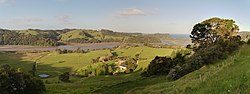
Mahurangi Regional Park is a regional park situated on the north-eastern coast of the Auckland Region of New Zealand's North Island. It is located in Rodney, north of the main Auckland urban area, and is owned and operated by Auckland Council.
2.5 km
Brazier Rock is an island off the east coast of the Auckland Region, New Zealand.

2.8 km
The Te Kapa River is on the Mahurangi Peninsula in the Auckland Region of New Zealand's North Island. It runs into the Mahurangi Harbour.

3.1 km
Casnell Island is an uninhabited island located in the Mahurangi Harbour, Auckland Region, New Zealand. Casnell Island is managed by the Department of Conservation.
3.3 km
The Puhoi River is a river of the Auckland Region of New Zealand's North Island. It flows southeast from its sources 10 kilometres southwest of Warkworth, passing through the town of Puhoi before reaching the coast of Whangaparaoa Bay seven kilometres north of Orewa.
Book your tour near
Te Haupa Island
→
