
 English
 Français

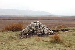
Hurst Hill
Hurst Hill is a location on Anglezarke Moor, within the West Pennine Moors of Lancashire, England. With a height of 317 metres (1,040 feet), the summit provides views towards the Irish Sea. It is located between Round Loaf and Pikestones, both of which are Neolithic remnants. It is probable that Hurst Hill (and nearby Grain Pole Hill) were vantage points for the ancient communities. No excavation work has taken place.
Nearby Places View Menu
606 m
Grain Pole Hill
Grain Pole Hill is a location on Anglezarke Moor, near Chorley, within the West Pennine Moors of Lancashire, England. With a height of 285 metres (935 ft), the summit provides views towards the Irish Sea. It is located between Round Loaf and Pikestones, both of which are Neolithic remnants. Hurst Hill is less than half a mile away.

761 m
Pikestones
Pikestones is the remains of a Neolithic Burial Cairn, located on Anglezarke moor in Lancashire, England. The site is approximately 150 feet (45 metres) long and 60 feet (18 metres) across at its widest point. It consisted of one burial chamber constructed of large upright slabs, capped by two lintel slabs, forming a chamber of 15 feet (4.5 metres) long, 3 feet (0.9 metres) wide and 3 feet (0.9 metres) high, covered by a huge mound of stones and turves. The cairn was aligned almost exactly North-South, with the burial chamber under the wider northern end. At the northern edge of the cairn, a double wall could be made out, curving inwards to form an entrance to a forecourt.
Today the cairn has been badly robbed and the main features are the five large gritstone slabs, the remains of the burial chamber.
Surprisingly, evidence suggests [which evidence] that the bodies were not interred directly in the tomb, but were left outside, perhaps at the entrance to the cairn, for birds and wild animals to consume the flesh and then, probably after elaborate ceremonies, the bones were placed inside the chamber.
Pikestones is the earliest man-made structure in the area and only one other chambered tomb has been found in Lancashire. The monument must have taken an immense amount of labour to construct and like most long barrows was erected in a prominent position, located on a ridge at a height of just over 900 feet (276 metres). This gave the Neolithic builders excellent views, and made the structure visible from a wide area of the Lancashire plain, perhaps warning other people that the land belonged to the builders.
1.2 km
Anglezarke
Anglezarke is a sparsely populated civil parish in the Borough of Chorley in Lancashire, England. It is an agricultural area used for sheep farming and is also the site of reservoirs that were built to supply water to Liverpool. The area has a large expanse of moorland with many public footpaths and bridleways. The area is popular with walkers and tourists; it lies in the West Pennine Moors in Lancashire, sandwiched between the moors of Withnell and Rivington, and is close to the towns of Chorley, Horwich and Darwen. At the 2001 census it had a population of 23, but at the 2011 census the population was included within Heapey civil parish. The area was subjected to depopulation after the reservoirs were built.

1.5 km
High Bullough Reservoir
High Bullough Reservoir is the oldest of all the reservoirs in the Rivington chain, having been authorised by an Act of Parliament obtained in 1846 and completed in 1850. It was built for Chorley Waterworks by the engineer John Frederick Bateman, who had estimated the cost of the project while working for Edwin Chadwick's Towns Improvement Company, and had then acted as Engineer for the project. The outlet consisted of a pipe running through the dam, and supported by two masonry piers where it ran through the central clay puddle. The outlet valve was at the downstream end of the dam, and although this configuration is no longer thought to be good practice, there have been no serious issues with the reservoir throughout its operational life. The earth dam had a maximum height of 39 feet (12 m), was 988 feet (301 m) long and impounded 55 million imperial gallons (250 Ml) of water.
Popular with walkers, it forms part of the Anglezarke trail, although it is also accessible from Manor House. It was originally named Chorley Reservoir. There are a number of websites that state that High Bullough Reservoir is no longer used to supply drinking water, but the reservoir was still contained in a list of reservoirs in the Rivington Chain when United Utilities issued an application for a drought permit to reduce compensation flows to the River Yarrow in mid-2018.
A huge staircase, made from timber, was created between the reservoir and nearby Manor House. Known as Jacob's Ladder, the remains can be seen on the east side of the water.