
 English
 Français

Ravenstonedale
Ravenstonedale is a village and large civil parish in Cumbria, on the watershed between the River Lune and River Eden. The village lies 4 miles (6 km) south west of Kirkby Stephen. The parish includes the village of Newbiggin-on-Lune and several smaller settlements including Bowderdale, Brownber, Greenside, Stennerskeugh, Wath and Weasdale. Large areas of moorland lie within the parish, extending 5 miles (8 km) south west of the village to the northern side of the Howgill Fells. The parish had a population of 570 in 2001, increasing to 594 at the 2011 Census. Historically also known as "Russendale", the parish is divided into four parts (known as 'angles'): Town, Newbiggin-on-Lune, Bowderdale and Fell End. The origin and toponymy of the name are obscure. An alternative spelling may be Rausyngdale The parish was historically in the county of Westmorland. Since 2016 it has been within the Yorkshire Dales National Park.
Nearby Places View Menu

St Oswald's Church, Ravenstonedale
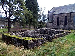
Ravenstonedale Priory

Ash Fell Edge
