
 English
 Français

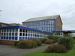
Longridge High School
Longridge High School is a coeducational secondary school located in Longridge in the English county of Lancashire. Previously a community school administered by Lancashire County Council, in October 2023 Longridge High School converted to academy status. The school is now sponsored by The Bay Learning Trust. Longridge High School offers GCSEs, BTECs and OCR Nationals as programmes of study for pupils.
Nearby Places View Menu
200 m
St Cecilia's Roman Catholic High School
St Cecilia's Roman Catholic High School is a coeducational secondary school in Longridge in the English county of Lancashire. The school is named after Saint Cecilia, the patroness of musicians. It is a voluntary aided school which is administered by Lancashire County Council and the Roman Catholic Diocese of Salford. St Cecilia's offers GCSEs and BTECs as programmes of study for pupils.
The current headteacher is Helen Hall, who was permanently appointed to the post in 2021 after serving as acting headteacher for four months.
The school was assessed as "good" by Ofsted in 2016 and again in 2019. The previous report, in 2013, said the school "required improvement" and the subsequent progression report in 2014 praised the school for taking effective action to take the school out of special measures.
The school gates were painted gold in 2017 in honour of Paralympian Stephanie Slater MBE, who had attended the school.

636 m
Longridge railway station (England)
Longridge railway station was a passenger terminus of the Preston and Longridge Railway. It served the town of Longridge in Lancashire, England.
The line first opened in 1840 to carry stone from the recently opened Tootle Heights quarry on the northeastern side of the village of Longridge, as it then was. Wagons carrying quarried stone ran downhill to Preston and were hauled in the other direction by horses. There were rudimentary passenger facilities at a level crossing in Burey Lane (later called Berry Lane) which at the time was a rural lane with only a couple of houses; the village of Longridge was at the southeast end of the lane. A hotel was built next to the station, and was known as the Longridge Railway Tavern and the Station Hotel before being renamed in 1853 the Towneley Arms, as it is still known today.
After the railway converted to steam power in 1848, Longridge expanded rapidly. Four cotton mills were built alongside the railway and Berry Lane became the town centre.
By 1867, the railway was owned jointly by the Lancashire and Yorkshire Railway and the London and North Western Railway, and three years later the railway bought the Towneley Arms. A station building was built on the side of the hotel in 1872.
On the opposite side of Berry Lane were many goods sidings, for the local mills, gasworks and a coal merchant. The line continued to the Tootle Heights quarries.
The line and the station closed to passengers on 31 May 1930. Goods traffic continued until November 1967; within the next year the tracks were lifted.
Today the former station building and canopy still exist and are used as the headquarters of Longridge Town Council. Where the tracks once ran through the station is a war memorial, erected in 1981. Part of the goods yard opposite has become a supermarket car park.
In late 2008, a Heritage Lottery Fund grant of £221,600 was awarded to restore the former station building for use as a heritage centre and community area. The restoration was completed in 2010.

743 m
St Paul's Church, Longridge
St Paul's Church stands off Berry Lane, Longridge, Lancashire, England. It is an active Anglican parish church in the diocese of Blackburn. The church was built in 1886–1888, and the tower was added in 1936–37. The church is recorded in the National Heritage List for England as a designated Grade II listed building.

865 m
Longridge
Longridge is a market town and civil parish in the borough of Ribble Valley in Lancashire, England. It is situated 8 miles (13 km) north-east of the city of Preston, at the western end of Longridge Fell, a long ridge above the River Ribble. The nearest villages are Grimsargh, 2 miles (3 km) to the southeast, and Ribchester 4 miles (6 km) to the southeast. The parish of Longridge had a population of 7,546 recorded in the 2001 census, increasing to 7,724 at the 2011 Census.