


The Stonar Cut German Wreck is the remains of the steel-hulled World War II German aircraft tender and air-sea rescue launch Blitz, located in the Stonar Cut near Sandwich, Kent.
Location
1 explorer visited this place

932 m
Richborough power station was a 336 MW power station close to the mouth of the River Stour near Sandwich, on the east coast of Kent. It was built on land within the Port of Richborough but being on the northern edge its site lies mostly within the neighbouring parish of Minster, Kent. It operated from 1962 to 1996; the towers were demolished on 11 March 2012. BFL Management Ltd, the current owners of the site plan to bring it back into use as the £750 million Richborough Energy Park.
1.0 km
Richborough Energy Park is a site of non-traditional power generation, on the site of the former Richborough power station close to the mouth of the River Stour near Sandwich, on the east coast of Kent, England.
1.1 km
Richboro Port railway station was constructed by the East Kent Light Railway, as part of its branch to Richborough Port, which never opened to passengers. Authorisation to operate a passenger service over the branch was never requested by the East Kent as it considered that the Port had first to develop before expenses could be outlaid on improving the branch's bridges over the Southern Railway and River Stour, which His Majesty's Railway Inspectorate would no doubt have required before giving its consent. The station was named Richboro Port, dropping the "ugh" off the end of Richborough, as witnessed by the nameboard on the station and contemporary maps.

1.3 km
South Thanet was a constituency in Kent.
The 2023 review of Westminster constituencies made moderate boundary changes to the constituency, which was renamed East Thanet, taking effect at the 2024 general election.
1.4 km
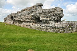
Richborough Castle is a Roman Saxon Shore fort better known as Richborough Roman Fort. It is situated in Richborough near Sandwich, Kent. Substantial remains of the massive fort walls still stand to a height of several metres.
It is part of a larger Roman town called Rutupiae or Portus Ritupis that developed around the fort and the associated port. The settlement was founded after the Roman conquest of Britain in AD 43. Because of its position near to a large natural harbour in the Wantsum Channel and to the mouth of the Stour, Rutupiae served as a main gateway to Roman Britain and the starting point for the road now known as Watling Street. The site is now 2+1⁄2 miles inland from the current coastline.
Earth fortifications were first dug on the site in the 1st century, probably for a storage depot and bridgehead for the Roman army. The site expanded into a major civilian and commercial town, and the stone Saxon Shore fort was added around the year 277. The later fort is believed to have been constructed by the rebel Carausius. The site is now under the care of English Heritage.
