


Kryovrysi (Greek: Κρυόβρυση, meaning cold spring) is a village located in the municipal unit of Perama, Ioannina regional unit, Greece. It is situated in the southeastern part of the Mitsikeli mountains, at the southeast edge of the Zagori region. Kryovrysi is 2.5 km north of Spothoi, 9 km east of Perama and 8 km northeast of Ioannina.
Location
1 explorer visited this place

4.0 km
East Zagori is a former municipality in the Ioannina regional unit, Epirus, Greece. Since the 2011 local government reform it is part of the municipality Zagori, of which it is a municipal unit. The municipal unit has an area of 269.657 km2. Population 1,113. The seat of the municipality was in Miliotades.

4.0 km
Mitsikeli is a mountain range in the central part of the Pindus mountains, in Epirus, Greece. The mountain is located northeast of Ioannina and Lake Ioannina. Its highest elevation is 1,810 m. It stretches from near Kalpaki in the northwest to the eastern end of Lake Ioannina, a total length of 35 km. The northeastern slopes and the lower northwestern part of Mitsikeli are forested. The nearest mountains are the Tymfi to the north, the Lygkos to the northeast and the Lakmos to the east. It is drained by tributaries of the Thyamis to the northwest, towards Lake Ioannina to the southwest, by the Voidomatis to the northeast and by the Arachthos to the southeast.
Mitsikeli forms the southwestern border of the Zagori region. Villages in the mountains include Kato Pedina and Asprangeloi in the northwest, Dikorfo and Perivleptos in the central part, and Kryovrysi in the southeast. The Greek National Road 6 passes south of the mountain, the Greek National Road 20 is to the west. The famous Perama Cave is to the southwest. There is a telecommunications tower on the summit.
4.9 km
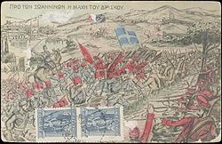
The Battle of Driskos, took place on 26–28 November, 1912. It was fought between Greek forces under General Dimitrios Matthaiopoulos and Ottoman forces under General Esad Pasha during the First Balkan War. The battle began when a unit of Greek Redshirt volunteers attacked the Ottoman defensive line at Mount Driskos, Epirus.
The Greeks seized the Ottoman camp and cleared its surroundings. On 27 November, the Ottomans regrouped after receiving considerable reinforcements in both manpower and artillery, launching an assault on Greek positions. The Greeks began withdrawing at noon the following day, after realizing that they were at risk of being overwhelmed. The Battle of Driskos marked the last intervention of the Redshirts into Greek expansionist conflicts.
5.1 km
The Μetsovitikos river is one of the primary tributaries of the Arachthos in Epirus, Greece. The mountainous basin through which it flows is distinguished into two sub-systems. The first one is the zone of the river springs.
History
In the area, a section of the ancient Via Egnatia that ran from Mazia to Baldouma has been preserved. The chapel of Agioi Anargyroi and the bridge near the locality of Kamper-Aga date back to Ottoman rule.
See also
List of settlements in the Ioannina regional unit