Location Image

Red Road (appartements)

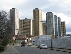
Les Red Road Flats étaient un ensemble de tours d'habitation du milieu du XXe siècle situé entre les districts de Balornock (en) et de Barmulloch (en), au nord-est de la ville de Glasgow, en Écosse. À l'origine, le lotissement se composait de huit blocs de plusieurs étages à ossature métallique. Tous ont été démolis en 2015. Deux d'entre eux étaient des "dalles", beaucoup plus larges en section transversale qu'elles ne sont profondes. Six étaient des "pointes", qui avaient plutôt la forme d'une tour traditionnelle. Les dalles avaient 28 étages (26 occupables et 2 mécaniques), les blocs de pointe 31 (30 occupables et 1 mécanique), et pris ensemble, ils étaient conçus pour une population de 4 700 personnes. Les blocs ponctuels étaient parmi les plus hauts bâtiments de Glasgow, avec 89 mètres, ce qui les plaçait au deuxième rang en termes de hauteur totale, derrière les anciennes tours Bluevale et Whitevale (en) de Camlachie (en). Le 30e étage des "Point Blocks" était le plus haut niveau habitable de tous les bâtiments de Glasgow. Les vues depuis les étages supérieurs ont attiré l'attention le long des Campsie Fells vers Ben Lomond et les Alpes d'Arrochar (en), puis vers l'ouest après le pont Erskine (en) et vers Goat Fell sur l'île d'Arran, en continuant vers le sud au-dessus de Glasgow et vers l'est en direction d'Edimbourg. Par temps clair, les bâtiments étaient visibles dans le ciel de Glasgow à une distance de 16 kilomètres. Le 31e étage des blocs de pointes et le 28e étage correspondant des dalles étaient réservés à une aire de séchage commune. Parmi les plus connus des tours d'habitation de Glasgow des années 1960, les bâtiments ont été officiellement condamnés en juillet 2008 après une longue période de déclin, leur démolition progressive se déroulant en trois étapes entre 2010 et 2015.

Nearby Places View Menu
Location Image
6 m

Red Road Flats

The Red Road Flats were a mid-twentieth-century high-rise housing complex located between the districts of Balornock and Barmulloch in the northeast of the city of Glasgow, Scotland. The estate originally consisted of eight multi-storey blocks of steel frame construction. All were demolished by 2015. Two were "slabs", much wider in cross-section than they are deep. Six were "points", more of a traditional tower block shape. The slabs had 28 floors (26 occupiable and 2 mechanical), the point blocks 31 (30 occupiable and 1 mechanical), and taken together, they were designed for a population of 4,700 people. The point blocks were among the tallest buildings in Glasgow at 89 metres (292 ft), second in overall height behind the former Bluevale and Whitevale Towers in Camlachie, but still held the record for having the highest inhabitable floor and the highest floor count of any building constructed in the city. Views from the upper floors drew the eye along the Campsie Fells to Ben Lomond and the Arrochar Alps, then west past the Erskine Bridge and out to Goat Fell on the Isle of Arran continuing south over Glasgow and East towards Edinburgh. On a clear day, the buildings were visible on the Glasgow skyline from up to 10 miles (16 kilometres) away. The 31st floor of the point blocks and the corresponding 28th floor of the slabs were reserved as a communal drying area. Among the best-known of Glasgow's highrise housing developments of the 1960s, the buildings were formally condemned in July 2008 after a long period of decline, with their phased demolition taking place in three stages between 2010 and 2015.
Location Image
404 m

Wallacewell

Wallacewell is a suburban area of the city of Glasgow, Scotland.
Location Image
404 m

Barmulloch

Barmulloch (; Scottish Gaelic: Barr a' Mhullaich) is a suburban area of the city of Glasgow, Scotland. It is situated north of the River Clyde. Formerly rural, it was developed as a post war overspill housing area, largely featuring prefabricated housing. Barmulloch shared the Red Road complex of multi-storey flats with the neighbouring district of Balornock prior to their demolition.
Location Image
495 m

St Roch's F.C.

St Roch's Football Club is a Scottish football club, based in Royston Road, Glasgow. Nicknamed "the Candy Rock", they were formed in 1920 and play at James McGrory Park. They currently compete in the West of Scotland League First Division. They wear green and white strips. St Roch's was the first club of Jimmy McGrory, the British record goalscorer with 550 goals. McGrory, who grew up in the Garngad area where the club originated, began playing for them aged just 11. After helping the club win the Scottish Junior Cup in 1922, scoring in the final, he joined Celtic the following season.
Location Image
762 m

All Saints Roman Catholic Secondary School

All Saints Roman Catholic Secondary School is a comprehensive, co-educational, Roman Catholic state school situated in Barmulloch the north-east of Glasgow, Scotland. Established in 1972, the school was rebuilt into a newer, more modern version in 2002, with better facilities but fewer classrooms. The headteacher is Brian McDermott.