


The Onkaparinga Surf Art Exhibition is an annual group art exhibition held at The Arts Centre, Port Noarlunga, South Australia. The event celebrates surfing and coastal culture in the state, and launches with a party featuring live music and in some years, screenings of surfing movies. In 2019, the event was held for the 26th time.
Book your tour near
Onkaparinga Surf Art Exhibition
Book Now
4.2
in partnership with
GetYourGuide.com
Location

279 m
Port Noarlunga is a suburb in the City of Onkaparinga, South Australia. It is a small sea-side suburb, with a population of 2,918, about 30 kilometres to the south of the Adelaide city centre and was originally created as a sea port. This area is now popular as a holiday destination or for permanent residents wishing to commute to Adelaide or work locally. There is a jetty that connects to a 1.6 kilometres natural reef that is exposed at low tide.
It is known as Tainbarang or Tainbarilla by the traditional owners, the Kaurna people, and is of significance as being the site of a freshwater spring said to be created by the tears of Tjilbruke, the creator being. A reserve known as the Tutu Wirra Reserve, on Witton Bluff, is the location of the stone cairn commemorating the second spring created by Tjilbruke on his journey down the coast.
The suburb is bounded to the south by the Onkaparinga River, including a tidal estuary. It is bounded to the west by the coastline with Gulf St Vincent, by Christies Beach to the north and by Noarlunga Centre and Noarlunga Downs to the east.
1.3 km
The John Bice Memorial Oval is a public park in the Australian state of South Australia located within the suburb of Christies Beach and which is used by the Christies Beach Football Club and Southern District Cricket Club as their home ground.
1.6 km
Port Noarlunga South is a suburb in the Australian state of South Australia located in the Adelaide metropolitan area on the coastline of Gulf St Vincent about 30 kilometres south of the state capital of Adelaide.
Port Noarlunga South started as a private sub-division in 1923 with portions gazetted with the names Paringa and Port Onkaparinga. A portion of land was added to the suburb in 1960 from an area known as Onkaparinga and was subsequently removed in 1995 to create the suburb of Seaford Meadows. In April 2001, the South Port Surf Life Saving Club submitted a proposal to rename parts of both the suburbs of Port Noarlunga and Port Noarlunga South as South Port. However, this proposal was withdrawn in August 2001 following discussions with the City of Onkaparinga regarding "locational identification issues " and replace with a request to "investigate the naming of South Port Beach."
Port Noarlunga South is bounded by the centre of the channel of the Onkaparinga River to the north, the coastline with Gulf St Vincent to the west, Aldam Road to the South and to the east by Commercial Road in part in the south, the centre of the Onkaparinga River in part and a line connecting both parts. Land use within the suburb consists of residential on its west side and 'open space' for land located within the Onkaparinga River Recreation Park on its east side.
Port Noarlunga South is located within the federal Division of Kingston, the state electoral district of Kaurna and the local government area of the City of Onkaparinga.

1.6 km
Christies Beach is a seaside suburb in the southern Adelaide metropolitan area, within the City of Onkaparinga. The area is scenic and hence popular with photographers as Witton Bluff provides a natural vantage point over the entire suburb and beyond.
Christies Beach boasts a unique commercial strip running the entire length of Beach Road and is identified as a primary coastal node in the Adelaide Metropolitan area. Christies Beach also features one of the few remaining main road classified Esplanades in Metropolitan Adelaide, providing direct access to the beach on Gulf St Vincent.
Christies Beach has its own postcode of 5165, and is adjacent to the suburbs of Christie Downs and Noarlunga Centre to the east, Port Noarlunga to the south, and O'Sullivan Beach to the north.
Offshore from Christies Beach is Horseshoe Reef, which is exposed at low tide. A new artificial subtidal reef was constructed approximately 500 metres offshore from the mouth of Christies Creek in 2021.
1.7 km
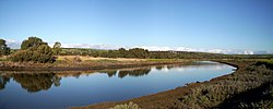
The Onkaparinga River, known as Ngangkiparri or Ngangkiparingga in the Kaurna language, is a river located in the Southern Adelaide region in the Australian state of South Australia. Rising in the Mount Lofty Ranges, the river's estuary extends from Old Noarlunga to the river's mouth between the suburbs of Port Noarlunga and Port Noarlunga South.