


Blowatz is a municipality in the Nordwestmecklenburg district, in Mecklenburg-Vorpommern, Germany.
Location
1 explorer visited this place

1.9 km
Krusenhagen is a municipality in the Nordwestmecklenburg district, in Mecklenburg-Vorpommern, Germany.

2.6 km
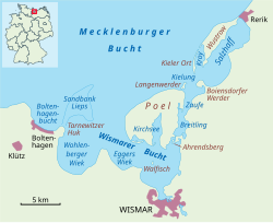
Reric or Rerik was one of the Viking Age multi-ethnic Slavic-Scandinavian emporia on the southern coast of the Baltic Sea, located near Wismar in the present-day German state of Mecklenburg-Vorpommern Reric was established probably in 735 shortly after Slavs of the Obodrite tribe had started to settle the region. At the turn of the 9th century, the citizens of Reric allied with Charlemagne, who used the port as part of a strategic trade route that would avoid areas of Saxon and Danish control. It was destroyed in 808 AD by the Viking king Gudfred. The destroyed place was rebuilt by the Obodrites and continued to operate for a short until Drasco was murdered in Reric in 810 at the instigation of Gudfred. After that, the tradespeople were reportedly moved by the king to the Viking emporium of Hedeby near modern Schleswig.
2.9 km
The Breitling is a narrow strait in the Baltic Sea between the island of Poel and the mainland in the northeast of the district of Nordwestmecklenburg. It links the sheltered part of the Bay of Wismar, beginning south of Poeldamm, with the Salzhaff.
The Breitling is a very shallow body of water, mostly under one metre in depth. Large parts can even become exposed at low water, whereas at high water it can cover the low-lying causeway known as the Poeldamm. In the south the road link runs along a causeway over a low peninsula to Poel over the Breitling. The waterbody is about five kilometres long and no more than one kilometre wide.

3.2 km
Ahrendsberg is an uninhabited island, 8.6 hectares in area, near the island of Poel in the Breitling, a strait off the Bay of Wismar on the Baltic coast of Germany.
The island, which is roughly 600 metres long and up to 220 metres wide, is dominated by salt meadows with shores that are dissected by creeks. The higher areas are generally very dry, nutrient-poor, and are characterised by stunted vegetation, for example dry, lean grassland with thistle and sand thyme. At the southern tip of the island is a short section of cliff.