
 English
 Français

Haugh of Urr
Haugh of Urr (), is a village in the historical county of Kirkcudbrightshire in Dumfries and Galloway, Scotland. It is approximately 4 miles (6 kilometres) NNW of Dalbeattie, 3 mi (5 km) NE of Castle Douglas, 12+1⁄2 mi (20 km) west of Dumfries and 12+1⁄2 mi (20 km) east of Kirkcudbright.
Nearby Places View Menu

2.0 km
Motte of Urr
The Motte of Urr is the remains of a 12th-century motte-and-bailey castle located near the Haugh of Urr in Dumfries and Galloway, Scotland.

2.4 km
Buittle railway station
Buittle railway station, also known as Buittle Halt, Buittle Mill and Buittle Mill Halt, served the civil parish of Buittle, Dumfries and Galloway, Scotland from 1862 to 1894 on the Castle Douglas and Dumfries Railway.

3.7 km
Springholm
Springholm is a village in the historical county of Kirkcudbrightshire in Dumfries and Galloway, Scotland. It is located 14 miles (23 km) west of Dumfries on the A75. The village has a primary school, which also serves for the local village of Kirkpatrick Durham. Springholm and Crocketford (2 miles or 3 km to the north-east) are the only two settlements that are not bypassed by the A75. The village is located in the historical county of Kirkcudbrightshire.
3.7 km
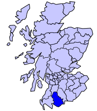
Stewartry
Stewartry was a local government district in the Dumfries and Galloway region of south-west Scotland between 1975 and 1996. The district covered the greater part of the historic county of Kirkcudbrightshire, whose alternative name, the Stewartry of Kirkcudbright, provided the district’s title.
Following the abolition of districts under the Local Government etc. (Scotland) Act 1994, the area became part of the unitary Dumfries and Galloway Council area in 1996. Under the name Stewartry of Kirkcudbright, the same area continues to be used as a lieutenancy area. Dumfries and Galloway Council maintains a Stewartry area committee whose jurisdiction broadly corresponds to the boundaries of the former district, although minor adjustments have been made where modern electoral ward boundaries differ from those in place prior to 1996.