
 English
 Français

Tunshill
Tunshill is a hamlet at the northeastern edge of Milnrow, within the Metropolitan Borough of Rochdale, in Greater Manchester, England. It lies amongst the foothills of the Pennines, 3.0 miles (4.8 km) east of Rochdale and 5.1 miles (8.2 km) north-northeast of Oldham. It includes a golf club and numerous farms. A small Roman statue of the goddess Victory was discovered at Tunshill Farm in 1793. In the 1970s, the M62 motorway was built through the area.
Nearby Places View Menu

626 m
Rakewood Viaduct
The Rakewood Viaduct carries the M62 motorway over Rakewood Valley and Longden End Brook between junctions 21 and 22 at Littleborough, Greater Manchester, England.
The viaduct is 280 yards (260 m) long and 140 ft (43 m) above the valley floor. It was built in 1966 by Reed & Mallik and opened to motorway traffic in October 1971. It has a sister bridge, the Gathurst Viaduct in Wigan, which carries the M6 motorway over the Leeds & Liverpool Canal, the Manchester-Southport line and the River Douglas and was constructed before the Rakewood Viaduct.
The steelwork deck was subcontracted to Robert Watson Steelwork of Bolton.
Due to the height of the bridge and the surrounding hillside exposure, it is often subject to high speed cross winds.

881 m
Rough Bank Farmhouse
Rough Bank Farmhouse is a Grade II* listed building in Newhey, a village in the town of Milnrow within the Metropolitan Borough of Rochdale, Greater Manchester, England. It is an early 17th-century farmhouse notable for its well-preserved vernacular architecture and historical significance as an example of a yeoman farmer's dwelling.
1.0 km
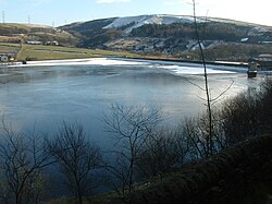
Ogden Reservoir (Greater Manchester)
Ogden Reservoir is a reservoir in the Piethorne Valley, close to Milnrow and Newhey in the Metropolitan Borough of Rochdale, within Greater Manchester, England.

1.1 km
Butterworth, Greater Manchester
Butterworth was a township occupying the southeastern part of the parish of Rochdale, in the hundred of Salford, Lancashire, England. It was also a civil parish. It encompassed 12.1 square miles (31 km2) of land in the South Pennines which spanned the settlements of Belfield, Bleaked-gate-cum-Roughbank, Butterworth Hall, Clegg, Haughs, Hollingworth, Kitcliffe, Lowhouse, Milnrow, Newhey, Ogden, Rakewood, Smithy Bridge, Tunshill and Wildhouse. It extended to the borders of Crompton to the south, and to the highest points of Bleakedgate Moor and Clegg Moor, up to the ridge of Blackstone Edge, to the east, where its boundary was the old county boundary between Lancashire and Yorkshire. In 1891 the parish had a population of 9438.
Butterworth was probably settled in Saxon times in the Early Middle Ages. Its land was divided into two divisions, the Lordship side with rents or services payable to the lord of the manor and the Freehold side that retained its importance until 1879 as a Registration district for births, deaths and marriages. In 1830, Butterworth was recorded to have 5,554 inhabitants.