
 English
 Français
Walkley
Walkley is a suburb of Sheffield, England, west of Burngreave, south of Hillsborough and north-east of Crookes. The area consists mainly of Victorian stone-fronted terraced housing and has a relatively high student population. It also has a number of independent shops and cafes.
Nearby Places View Menu

296 m
Walkley Library
Walkley Library is a public lending library in Walkley, a suburb of the City of Sheffield in England. It stands at the junction of Walkley Road and South Road in one of the busiest parts of the area. It is one of 27 suburban branch libraries within the city. The building is a Carnegie library, the only library in Sheffield to receive Carnegie funding, it is also a Grade II listed building as are the boundary walls and commemorative plaque in front of the library.

647 m
Crookes & Crosspool (ward)
Crookes & Crosspool ward—which includes the districts of Crookes, Steelbank, Crosspool, and Sandygate —is one of the 28 electoral wards in City of Sheffield, England. It is located in the western part of the city and covers an area of 3.9 km2. The population of this ward in 2011 was 17,700 people in 7,266 households.
The current councillors for Crookes and Crosspool Ward are Minesh Parekh (Labour and Co-operative), Ruth Milsom (Labour), and Tim Huggan (Liberal Democrats).
Crookes and Crosspool ward is mostly located within Sheffield Hallam Parliamentary constituency. The local MP is Labour's Olivia Blake, who won the seat in December 2019. Parts of the ward also cross into the Sheffield Central constituency, represented by Labour's Paul Blomfield
689 m
Bolehill Recreation Ground
Bolehill Recreation Ground, known locally as The Bole Hills is a public open space in the suburb of Crookes within the City of Sheffield, England. The grounds are administered by Sheffield City Council's Parks and Countryside Service and are classed as a district park, one of 20 throughout the city. They are spread over an area of approximately 12 hectares (30 acres), consisting of a mixture of heathland, scrub and woodland and have been designated as a Local Wildlife Site. There are also several public amenities such as a children's playground, tennis courts, bowling greens and hut and a BMX track. The grounds stand at height of around 200 metres (660 feet) and offer good views to the north and west over the Loxley and Rivelin valleys.
778 m
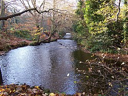
River Rivelin
The River Rivelin is a river in Sheffield, South Yorkshire, England.
It rises on the Hallam moors, in north west Sheffield, and joins the River Loxley (at Malin Bridge). The Rivelin Valley, through which the river flows, is a 3+1⁄2-mile (5.6 km) long woodland valley that includes the popular Rivelin Valley Nature Trail that was created in 1967. The valley has farmland on its gentler upper slopes. Tributaries include the Wyming Brook, Allen Sike and the Black Brook. The Rivelin Dams are to be found at the head of the valley.
A relatively fast-flowing river (it drops 80 metres (260 ft) between Rivelin Mill Bridge and Malin Bridge), the Rivelin is fed by a constant release of water from the nearby moorland peat. Its flow was exploited for centuries as a power source, driving the water wheels of up to twenty industries (forges, metal-working and flour mills) along its course.