
 English
 Français

Beinn Mhic-Mhonaidh
Beinn Mhic-Mhonaidh (796 m) is a mountain in the Grampian Mountains of Scotland, west of Glen Orchy in Argyll and Bute. Climbs usually start from the Eas Urchaidh waterfall in Glen Orchy. The peak has forested lower slopes and provides superb views from its summit.
Nearby Places View Menu

5.6 km
Glen Orchy
Glen Orchy (Scottish Gaelic: Gleann Urchaidh) is a glen in Argyll and Bute, Scotland. It runs from Bridge of Orchy to Dalmally.
7.0 km
Loch Dochard
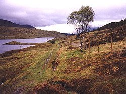
Loch Dochard is an upland freshwater loch lying approximately 6 km (3.7 mi) west of Bridge of Orchy in Argyll and Bute, Scottish Highlands. The loch has an irregular shape with a perimeter of 3 km (1.9 mi). It is approximately 1.06 km (0.66 mi) long, has an average depth of 3.7 m (12 ft) and is 13 m (42 ft) at its deepest. The loch was surveyed on 18 May 1903 by Sir John Murray and later charted as part of his Bathymetrical Survey of Fresh-Water Lochs of Scotland 1897-1909.

7.3 km
Beinn Udlaidh
Beinn Udlaidh (840 m) is a mountain in the Grampian Mountains, Scotland. It is located near the village of Tyndrum in Argyll and Bute.
The mountain has a plateaued summit, which has been scarred by corries on its northern side. Also on its northern side, a quartzite dyke descends from the summit ridge all the way down to Glen Orchy.
7.4 km
River Lochy (Glen Lochy)
The River Lochy flows west through Glen Lochy from Loch Bhe to the River Orchy and hence Lochawe in the West Highlands of Scotland.
The A85 road parallels the river for much of its length, as does the West Highland Line from Crianlarich to Dalmally.