


La gare de Przemyśl (en polonais : Przemyśl Główny) est une gare ferroviaire polonaise, située sur le territoire de la ville de Przemyśl.
Gallery


Sponsored
Location
1 explorer visited this place

44 m
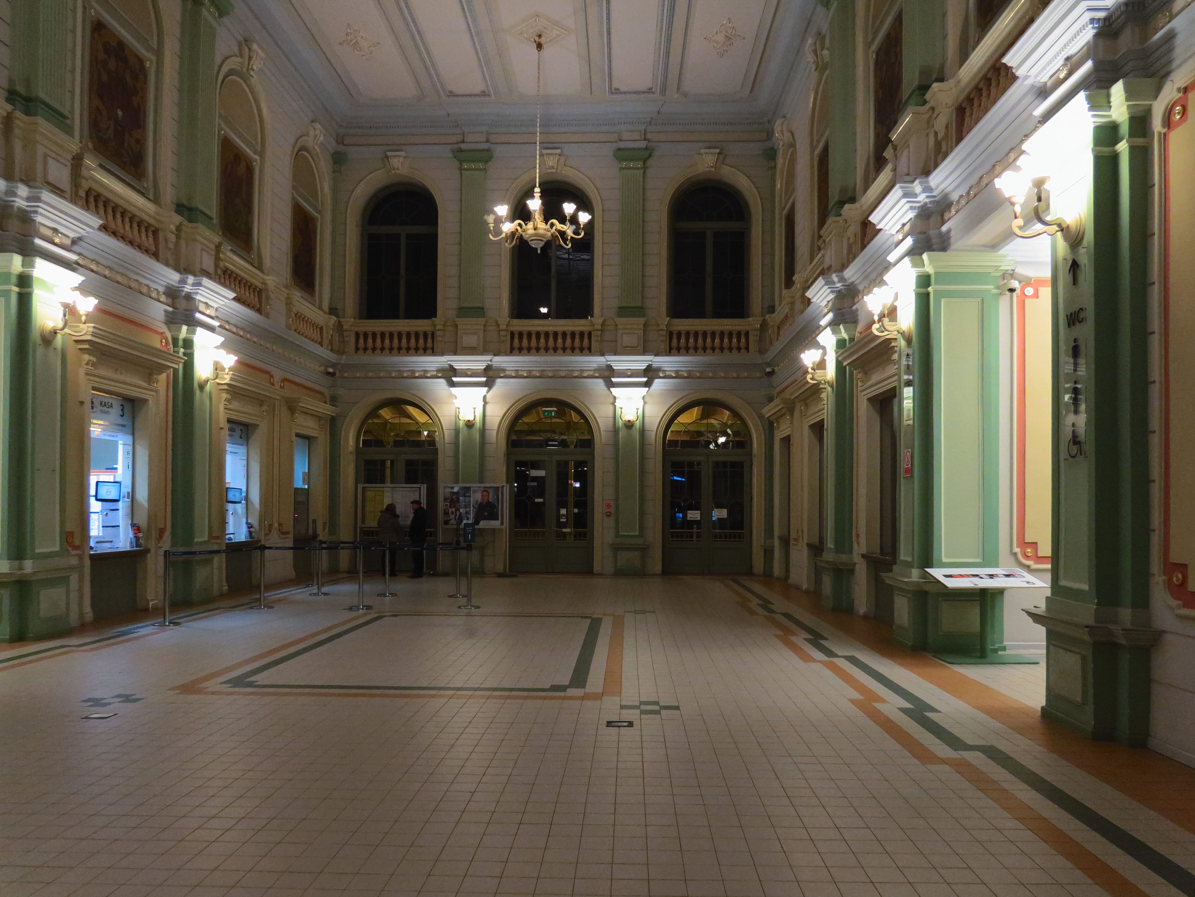
Przemyśl Główny is the chief railway station serving the city of Przemyśl, in the Subcarpathian Voivodeship, Poland.
The station was opened in 1860 as part of the Galician Railway of Archduke Charles Louis and is located about 15 km from the border with Ukraine at Medyka-Shehyni. It has standard gauge tracks for connections to the rest of Poland, as well as broad gauge tracks for the connection with Ukraine. Hence it serves as an important junction between the railway systems of Poland and Ukraine.
After the 2022 Russian invasion of Ukraine it has become an important transfer point for refugees leaving Ukraine, with about 500,000 refugees passing through the station in the first month of the war.
The station serves a wide range of regional, domestic, and international connections. As of the end of 2025, it maintained direct services to seven European capitals: Berlin, Bratislava, Budapest, Kyiv, Prague, Warsaw, and Vienna.

297 m
The New Synagogue, also called Scheinbach’s Synagogue, is a former Orthodox Jewish congregation and synagogue, located at Juliusza Słowackiego 15, in Przemyśl, in the Podkarpackie Voivodeship of Poland. Designed by Stanisław Majerski and completed in 1918, the synagogue served as a house of prayer until World War II when it was desecrated by Nazis in 1939.
Since 1967, the building has been used as the Ignacy Krasicki Przemyśl Public Library.

356 m
Przemyśl Land was an administrative unit of Kyivan Rus, Kingdom of Poland and Polish–Lithuanian Commonwealth. It existed since the integration of Principality of Peremyshl into Kingdom of Ruthenia and until 1772, and was one of five lands of Poland's Ruthenian Voivodeship. Its capital was at Przemyśl, where local sejmiks also took place. Together with Red Ruthenia, Przemyśl Land was annexed by King Kazimierz Wielki in 1340. It remained part of Poland in unchanged form until 1772, when, following the first partition of Poland, it became of Habsburg's province of Galicia.
In the 15th century, Przemyśl Land was divided into the following counties: Przemyśl, Jarosław, Leżajsk, Łańcut, Mosciska, Rzeszów, Przeworsk, Sambor, Drohobycz, Stryj, Tyczyn and Zydaczow. By the 17th century, the number of counties was reduced to four. According to the 1676 royal census, Przemyśl Land had 32 towns and 980 villages.
Przemyśl Land had the area of 12,070 km2; more than half of which was County of Przemyśl). Sambor County had the area of 2,700 km2, Stryj County – 1,600 km2, and Drohobycz County – only 700 km2. In comparison to historic Lesser Polands voivodeships, Przemyśl Land was quite extensive – it was larger than neighboring Lublin Voivodeship, and half the size of Sandomierz Voivodeship. Boundaries of Przemyśl Land were not at first precise, so in 1541 royal commission marked its border with Lwów Land, in 1554 the border with Sanok Land was also marked. Some time in the mid-17th century, Przeworsk County was re-created out of northwestern part of Przemyśl County. It was densely populated, with 237 villages and 11 towns, and had its own tax office, located at Przeworsk.
Zygmunt Gloger gave the following description of Przemyśl Land:
"Przemyśl Land was divided into two counties: those of Przemyśl and Przeworsk In 1676, County of Przemyśl had 18 towns and 657 villages, while County of Przeworsk had 18 towns and 221 villages.
Przemyśl, known in Latin as Praemislia, and in Ruthenian as Peremysl, is located on the San river. It had an ancient castle and two cathedral churches – Roman-Catholic and Greek-Catholic. Przemyśl is one of the oldest towns, mentioned by Nestor the Chronicler, who wrote that before 981, it belonged to Poland. Since in those years gords were named after their founders, we can assume that it was named after a Lechite Duke Przemyslaw. Among towns of Przemyśl Land there also is Medyka, where in 1434 King Wladyslaw Jagiello listened to a nightingale, caught a cold and died at Grodek Jagiellonski.

356 m
Przemyśl Voivodeship was a unit of administrative division and local government in Poland that existed from 1975 to 1998, superseded by the Podkarpackie Voivodeship. Its capital city was Przemyśl.

356 m
Przemyśl fortress is a series of fortifications around Przemyśl, Poland. It was constructed by the Austro-Hungarian Empire from the mid 19th century until the First World War in sections, depending on the diplomatic relations between Austria and the Russian Empire, and saw extensive combat during World War I. Originally captured by the Russian Army, it was recaptured by the German Army in mid-1915. Afterwards the ruined fortifications lost their military significance.
Book your tour near
Gare de Przemyśl
Book Now
4.4
in partnership with
GetYourGuide.com
