Location Image

Bataille de Nechtansmere

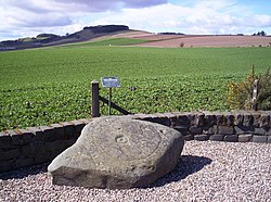
La bataille de Dun Nechtain ou bataille de Nechtansmere se déroule le 20 mai 685. Elle oppose les Pictes du roi Bridei mac Bili aux Northumbriens du roi Ecgfrith et se solde par une défaite écrasante des seconds. Cherchant à raffermir l'hégémonie exercée par ses prédécesseurs sur les Pictes, Ecgfrith s'enfonce dans le territoire picte contre l'avis de ses conseillers. Il tombe dans une embuscade en pourchassant les troupes pictes qui feignent de battre en retraite. L'affrontement coûte la vie à la majeure partie de l'armée northumbrienne, ainsi qu'à Ecgfrith lui-même. Grâce à cette bataille, les Pictes assurent définitivement leur indépendance vis-à-vis de la Northumbrie. Depuis le début du XIXe siècle, le champ de bataille est situé à Dunnichen, dans l'Angus. Une théorie alternative plus récente propose de le situer plus au nord, à Dunachton dans le Badenoch.

Nearby Places View Menu
Location Image
360 m

Dunnichen

Dunnichen (Scots pronunciation: [dəˈnɪxən]; Scottish Gaelic: Dùn Eachain) is a small village in Angus, Scotland, situated between Letham and Forfar. It is close to Dunnichen Hill, at which the Battle of Dun Nechtain is popularly believed to have been fought. The church is part of the parish of Letham, Dunnichen and Kirkden.
1.1 km

Bowriefauld

Bowriefauld is a small village in Angus, Scotland. To the north of Bowriefauld is Dunnichen and to the east is Letham. The village has several old cottages. Dunnichen cemetery is on the northern edge of the village.
Location Image
1.8 km

Letham, Angus

Letham (Scots pronunciation: [ˈlɛθəm]) is a village in Angus, Scotland. Letham is the largest village in Angus, with a population of nearly 2,000. Situated 17 miles (27 km) from Dundee, 5 miles (8.0 km) from Forfar, 10 miles (16 km) from Arbroath and 10 miles (16 km) from Carnoustie. There are some shops, including two groceries, one of which incorporates the Post Office and newsagent, a primary school, a bakery, a hairdresser, a take-away restaurant, a former hotel which now only functions as bar, the Commercial Inn and a widely known craft shop. The village is part of the parish of Letham, Dunnichen and Kirkden. In and around the Village is an extensive pattern of green paths which are kept cut by a group of volunteers, giving the village many and varied places to walk. . Many organisations and groups exist to enhance village life, the oldest of these being the Feuars Committee, which manages properties, held in trust for the people of the village. Nearby is the village of Dunnichen, which is widely believed to be the site of the Battle of Nechtansmere, and the Hamlets of Bowriefauld and Craichie. To the north of the village there is a Pictish stone with a cup and ring marking, locally known as the Girdlestane. Pictish stones have been found in many sites in Angus. Letham is twinned with Monasterboice, County Louth, Ireland.
Location Image
1.8 km

Craichie

Craichie (Scots pronunciation: [ˈkɾeːxe]) is a hamlet in the parish of Dunnichen, Angus, Scotland. Craichie is three miles south-east of Forfar and two miles south-west of Letham, at a junction on the B9128 Carnoustie to Forfar road.
2.5 km

Kingsmuir railway station

Kingsmuir railway station served the village of Kingsmuir, Angus, Scotland, from 1870 to 1955 on the Dundee and Forfar direct line.