
 English
 Français

Kearsley Mill
Kearsley Mill is a 240,000 sq ft (22,000 m2), late period cotton mill located in the small village of Prestolee in Kearsley, Greater Manchester, part of the historic county of Lancashire. A near complete example of Edwardian mill architecture, the building now functions as headquarters for a number of businesses and is still used in the continued manufacturing and distribution of textiles by Richard Haworth Ltd Est (1876), part of the Ruia Group. The mill is a Grade II listed building.
Nearby Places View Menu

328 m
Kearsley railway station
Kearsley railway station serves the town of Kearsley and the outlying villages of Stoneclough, Prestolee and Ringley in Greater Manchester, England. It was originally named Stoneclough.
It lies on the Manchester-Preston Line 7+3⁄4 miles (12.5 km) north of Manchester Victoria, though only local services run by Northern Trains stop here.
The station was staffed until the early 1990s, however the arson attacking of the station building just below platform level saw an end to this arrangement. In the spring of 2015, the station's pedestrian rail crossing was replaced by a footbridge and the platforms rebuilt as part of modernisation work to electrify the line and raise line speeds to 100 mph.
426 m
Prestolee
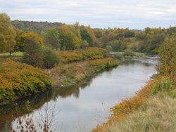
Prestolee is a small village in Kearsley, within the Metropolitan Borough of Bolton, in Greater Manchester, England. It lies on the River Irwell and is one of a cluster of villages between Bolton and Kearsley, which includes Stoneclough and Ringley. It is dubbed the "Island Village" as it is surrounded on all sides by water.
Historically part of Lancashire, during the Middle Ages, Prestolee was a chapelry within the ancient ecclesiastical parish of Prestwich-cum-Oldham. In Wilson's 1870–1872 Imperial Gazetteer of England and Wales it is described as having a population of about 1,600.
Prestolee is surrounded almost completely by water and is effectively an island, with the River Irwell to the north, west and south and the Manchester, Bolton and Bury Canal to the northeast. There is one road (Bridge Street) that provides vehicle access over the River Irwell. Prestolee Road also allows access to the village via a small canal bridge but the road is not metalled and not practical for most vehicles. Pedestrian access from the north is facilitated by using Prestolee Aqueduct, a grade II listed structure which carries the canal over the river, or the nearby Pack Horse Bridge. Prestolee Locks were on the Bury branch of the canal, which has been disused since a breach in 1936.
The area around Prestolee forms part of various countryside walks with particular focus upon the industrial heritage of this region. Not long ago the area was severely damaged by pollution but with the coming of the Clean Air Act and the demise of the cotton mills the river has once again regained its fish and other wildlife and wildflowers abound.
It has a grade II listed parish church (Holy Trinity). This was used by TV show Coronation Street as a venue for many weddings and known to fans as All Saints' Church, Weatherfield. It also has a primary school.
Another other major landmark is the grade II listed Kearsley Mill, a cotton spinning mill in its previous guise, now home to several industrial uses. It is described by English Heritage as "A near-complete example of an early C20 spinning mill designed specifically to be powered by electricity generated on site, by steam turbine generators." At one time there were also two other mills on the banks of the Irwell to the right of the road bridge from Stoneclough, though these mills were demolished in the 1970s to make way for housing. Prestolee has various shops in or just outside the village, including a greengrocer's, a chip shop (now a takeaway) and a sweet shop later becoming a butcher's before ending as a village community centre. There is a pub, the Grapes Hotel, to the Stoneclough end of the bridge and several others in the near vicinity.
Prestolee has a small primary school. The book The Idiot Teacher by Gerard Holmes tells the history of the school, run for very many years by Edward "Teddy" O'Neill (1890-1975), who believed children should be self-directed in their education.
Prestolee Wood is a small woodland (3 ha (7.4 acres)) owned by the Woodland Trust, beside the A667 road to the east of the village, north of the river and the canal.
490 m
River Croal
The River Croal is a river located in Greater Manchester, England. It is a tributary of the River Irwell.
Rising at the confluence of Middle Brook and Deane Church Brook, it flows eastwards through Bolton, collecting Gilnow Brook and the larger River Tonge at Darcy Lever. Most of the river is culverted through Bolton town centre, running under Knowsley Street, Market Place and Bridge Street.
Before 1836, the River Croal formed the boundary between the townships of Great and Little Bolton.
The name of the river is derived from the Old English croh and wella, the winding stream. It was possibly originally called the Middlebrook along its entire length as early references mention the Mikelbrok, (mycel and broc), the great stream but not the Croal.
It meets the Irwell at Nob End, Kearsley after a total course of around ten miles.

556 m
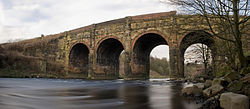
Prestolee Aqueduct
Prestolee Aqueduct is a stone-built aqueduct in Prestolee, Kearsley in the Metropolitan Borough of Bolton, Greater Manchester, England. The four-arch structure was constructed in 1793 to carry the Manchester, Bolton and Bury Canal across the River Irwell. It is now preserved as a Grade II listed building.
The aqueduct is one of two remaining major structures on the canal, the other being the Clifton Aqueduct. A third major aqueduct, Damside Aqueduct, was demolished in the 1950s.
As of 2007, the aqueduct still carried water, although it was not navigable as adjoining sections of the canal are in need of restoration.