
 English
 Français

Château de Doune
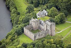
Le château de Doune (en anglais Doune Castle) est un château médiéval situé au cœur de l’Écosse, au confluent de la rivière Teith et de la rivière Forth, non loin du village de Doune, à 13 km au nord-ouest de Stirling. Ce château est également connu pour avoir été un des lieux de tournage de plusieurs fictions, dont Monty Python : Sacré Graal !
Nearby Places View Menu
0 m
Doune Castle
Doune Castle is a medieval stronghold near the village of Doune, in the Stirling council area of central Scotland and the historic county of Perthshire. The castle is sited on a wooded bend where the Ardoch Burn flows into the River Teith. It lies 8 miles (13 kilometres) northwest of Stirling, where the Teith flows into the River Forth. Upstream, 8 miles (13 kilometres) further northwest, the town of Callander lies at the edge of the Trossachs, on the fringe of the Scottish Highlands.
Recent research has shown that Doune Castle was originally built in the 13th century, then probably damaged in the Scottish Wars of Independence, before being rebuilt in its present form in the late 14th century by Robert Stewart, Duke of Albany (c. 1340–1420), the son of Robert II of Scotland, and Regent of Scotland from 1388 until his death. Duke Robert's stronghold has survived relatively unchanged and complete, and the whole castle was traditionally thought of as the result of a single period of construction at this time. The castle passed to the crown in 1425, when Albany's son was executed, and was used as a royal hunting lodge and dower house. In the later 16th century, Doune became the property of the Earls of Moray. The castle saw military action during the Wars of the Three Kingdoms and Glencairn's rising in the mid-17th century, and during the Jacobite risings of the late 17th century and 18th century. By 1800 the castle was ruined, but restoration works were carried out in the 1880s, prior to its passing into state care in the 20th century. It is now maintained by Historic Environment Scotland.
Due to the status of its builder, Doune reflected the then current ideas of what a royal castle building should be. It was planned as a courtyard with ranges of buildings on each side, although only the northern and north-western buildings were completed. These comprise a large tower house over the entrance, containing the rooms of the Lord and his family, and a separate tower containing the kitchen and guest rooms. The two are linked by the great hall. The stonework is almost all from the late 14th century, with only minor repairs carried out in the 1580s. The restoration of the 1880s replaced the timber roofs and internal floors, as well as interior fittings.

451 m
Ardoch Burn
The Ardoch Burn is a stream in Stirling council area, Scotland, which flows from the Braes Of Doune into the River Teith at Inverardoch, just behind Doune Castle.

565 m
Doune
Doune (; from Scottish Gaelic: An Dùn, meaning 'the fort') is a burgh within Perthshire. The town is administered by Stirling Council. Doune is assigned Falkirk postcodes starting "FK". The village lies within the parish of Kilmadock and mainly within the area surrounded by the River Teith and Ardoch Burn.
In the 2001 Scottish census, 2.75% residents of Doune could speak Scottish Gaelic.
Doune has a small primary school with 183 pupils on the roll (June 2016), drawn from a catchment area which extends outside the town, especially to the north. It is located on the site of Doune Roman fort. Gaelic is taught in Primary 1–7 and Spanish is now taught from P5 upwards .

841 m
Doune railway station
Doune was a railway station located in Doune, in the council area of Stirling, Scotland.
The station was rebuilt in typical Caledonian Railway style in the early 1900s after the completion of the Callander and Oban Railway in 1880. It closed on 1 November 1965 and was demolished around 1968. The site was used by a timber merchant for many years. In the late 1990s a private housing estate was built on the station site. Although little or no trace of the station remains, the station house still stands at the entrance to the housing development.

1.2 km
Menteith
Menteith or Monteith (Scottish Gaelic: Tèadhaich) is a district of south Perthshire, Scotland, roughly comprises the territory between the Teith and the Forth. Historically, the area between Callander and Dunblane was known in English by the similar name of the "Vale of Menteith".
Menteith encompasses the parishes of Callander, Aberfoyle, Port of Menteith, Kippen, Kilmadock, Kincardine, Lecropt and Dunblane.