
 English
 Français
Galloway
Galloway (Gall-ghaidhealaibh ou Gallobha en gaélique écossais, Gallowa en scots) désigne aujourd'hui l'ancien comté de Wigtownshire (délimité par la côte à l'ouest, les collines de Galloway au nord, et le fleuve Cree à l'est) et la Stewartry of Kirkcudbright (qui s'étend du Nith au Cree, et est limité également par les collines de Galloway au Nord) dans le sud-ouest de l'Écosse, mais dont la taille a beaucoup varié au cours de l'Histoire. Il constitue une partie du council area de Dumfries and Galloway. Ce nom est également donné à une robuste race de bœufs noirs sans cornes, originaire de la région. Galloway a toujours été relativement isolé en raison de ses 250 km de côtes accidentées et de ses vastes collines inhabitées du nord.
Nearby Places View Menu
21 m
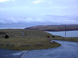
Galloway
Galloway (Scottish Gaelic: Gall-Ghàidhealaibh [ˈkal̪ˠaɣəl̪ˠu]; Scots: Gallowa; Latin: Gallovidia) is a region in southwestern Scotland comprising the historic counties of Wigtownshire and Kirkcudbrightshire. It is administered as part of the council area of Dumfries and Galloway.
Galloway is bounded by sea to the west and south, the Galloway Hills to the north, and the River Nith to the east; the border between Kirkcudbrightshire and Wigtownshire is marked by the River Cree. The definition has, however, fluctuated greatly in size over history.
A native or inhabitant of Galloway is called a Gallovidian. The region takes its name from the Gall-Gàidheil, or "stranger Gaels", a people of mixed Gaelic and Norse descent who seem to have settled here in the 10th century. Galloway remained a Gàidhealtachd area for much longer than other regions of the Scottish Lowlands and a distinct local dialect of the Scottish Gaelic language survived into at least the 18th century.
A hardy breed of black, hornless cattle named Galloway cattle is native to the region, in addition to the more distinctive Belted Galloway or "Beltie".

1.5 km
Kenmure Castle
Kenmure Castle is a fortified house or castle in The Glenkens, 1 mile (1.6 km) south of the town of New Galloway in Kirkcudbrightshire, Galloway, south-west Scotland. The site was occupied from the Middle Ages, and the house incorporates part of a 17th-century castle. This was remodelled in the 19th century, but the house has been derelict since the mid-20th century. It was the seat of the Gordon family of Lochinvar, later raised to the peerage as Viscounts of Kenmure. The ruin is a scheduled monument.

2.1 km
Water of Ken
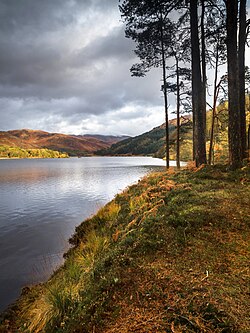
The Water of Ken is a river in the historical county of Kirkcudbrightshire in Galloway, south-west Scotland.It rises on Blacklorg Hill, north-east of Cairnsmore of Carsphairn in the Carsphairn hills, and flows south-westward into The Glenkens, passing through Kendoon, Carsfad and Earlstoun lochs, all of which are dammed to supply the Galloway Hydro Electric Scheme. At Kendoon Dam the Ken is joined by a major tributary the Water of Deugh. From there, the river flows south, passing St. John's Town of Dalry and New Galloway, before widening to form the 9-mile long Loch Ken.The Black Water of Dee also enters halfway down the loch, and from Glenlochar, at the south end of the loch, the river continues as the Dee towards Kirkcudbright and the coast.
There are a number of interesting bridges over the Water of Ken. Smeaton's Bridge (sometimes Smitton's Bridge) carries the B729 road which runs between Carsphairn and Moniaive. It crosses the Ken a half mile above the confluence of the Stroanfreggan burn. This bridge has a single arch 42 ft long.
A few miles further downstream the High Bridge of Ken spans the river at a narrow ravine on the B7000 back road from Carsphairn to St John's Town of Dalry. The bridge has 2 arches each 24 ft long. British listed buildings website describes the bridge as early 18th century, possibly earlier origin.
Further downstream again the Ken Bridge lies between St John's Town of Dalry and New Galloway.This bridge carries the A712 road and dates from 1822. It has 5 granite arches and is 340 ft long. Immediately adjacent to the bridge is the Ken Bridge Hotel.

2.6 km
New Galloway
New Galloway (Scottish Gaelic: Gall-Ghàidhealaibh Nuadh) is a town in the historical county of Kirkcudbrightshire in Dumfries and Galloway. It lies on the west side of the valley of the Water of Ken, 1 mile (2 kilometres) north of the end of Loch Ken. Before the local government reform of 1975, it was the smallest Royal Burgh in Scotland.

2.6 km
New Galloway Town Hall
The New Galloway Town Hall is a municipal building in Dumfries and Galloway, Scotland, situated on the town's high street. A tolbooth has existed on the site of the current building since at least 1711; in 1875, it was rebuilt and enlarged. In 1971 it was designated a Category B listed building.