
 English
 Français
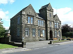
Denny Town House
Denny Town House is a municipal building in Glasgow Road, Denny, Falkirk, Scotland. The structure is used by Falkirk Council for the provision of local services.
Nearby Places View Menu

45 m
Denny railway station
Denny railway station served the town of Denny, Falkirk, Scotland from 1858 to 1930 on the Scottish Central Railway.
323 m
Denny, Falkirk
Denny (Scottish Gaelic: an Daingneach) is a town in the Falkirk council area of Scotland. Historically in Stirlingshire, it is situated 7 miles (11 kilometres) west of Falkirk, and 6 miles (10 km) northeast of Cumbernauld, adjacent to both the M80 and M876 motorways. At the 2011 census, Denny had a resident population of 8,300.

615 m
Denny High School
Denny High School in Scotland is a non-denominational public secondary school. The school was opened in 1959, and moved to a new building in February 2009. The new school contains a gymnasium, swimming pool and drama studio. The school serves an area of 25 square miles (65 km2) around the area of Denny, Falkirk, including Bonnybridge, Dunipace, Banknock and Dennyloanhead. In 2004, Denny High School had a roll of 1316 pupils and 95 teachers. It also employed 34 non-teaching staff.

904 m
Dunipace
Dunipace (Scottish Gaelic: Dùn a' Phais "The hill-fort of the pass") is a village in the west of the Falkirk council area of Scotland. The village is 6.3 miles (10.1 km) south of Stirling and 5.3 miles (8.5 km) north-west of Falkirk. The village is situated on the north bank of the River Carron and adjoins the town of Denny, to the south of the river. Dunipace is part of the historic county of Stirlingshire.
The main road through Dunipace is the A872 road between Denny and Stirling. Based on the 2001 census, Falkirk council reported the population of Dunipace as being 2,444 residents.