
 English
 Français

Polmont railway station
Polmont railway station is a railway station serving the village of Polmont, Scotland as well as the other Falkirk Braes villages. It is located on the Glasgow to Edinburgh via Falkirk Line and is also served by ScotRail services from Edinburgh to Stirling and Dunblane. It is the nearest station to much of the town of Grangemouth.
Nearby Places View Menu

451 m
Brightons
Brightons is a village in the east of the Falkirk council area of Scotland. It is 2.7 miles (4.3 km) south-east of Falkirk, 2.2 miles (3.5 km) south of Grangemouth and 4.6 miles (7.4 km) west of Linlithgow. It is surrounded by the villages of Polmont, Wallacestone and Rumford. It is central within the Braes area of Falkirk which makes it “Capital of the Braes”
810 m
Falkirk Braes
The Falkirk Braes is a geographical and sociopolitical entity within the Falkirk local authority area in Scotland. The population (both suburban and rural) is approximately 32,000 (2018), about 20% of the total for Falkirk council area.
867 m
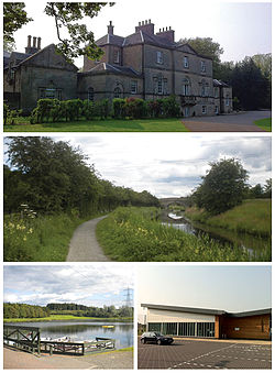
Polmont
Polmont (Scottish Gaelic: Poll-Mhonadh) is a village in the Falkirk council area of Central Scotland. It lies towards the east of the town of Falkirk, north of the Union Canal, which runs adjacent to the village.
Due to its situation in Central Scotland, many locations can be seen from Polmont, ranging from the Ochil Hills and the River Forth, to Cairnpapple Hill. Although giving its name to Polmont Young Offenders Institution, the prison is in fact in Reddingmuirhead.

898 m
Redding, Falkirk
Redding is a village within the Falkirk council area in Central Scotland. The village is 2.1 miles (3.4 km) southeast of Falkirk, 1.9 miles (3.1 km) south-southwest of Grangemouth and 1 mile (1.6 km) west of Polmont.
At the time of the 2001 census, Redding had a population of 1,954 residents.