
 English
 Français

Romiley railway station
Romiley railway station serves Romiley, in the Metropolitan Borough of Stockport, Greater Manchester, England. It is sited at a junction of two parts of the Hope Valley Line, providing services between Manchester Piccadilly, New Mills Central and Sheffield, and also between Piccadilly and Rose Hill Marple.
Nearby Places View Menu
438 m
Romiley
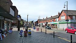
Romiley is a village in the Metropolitan Borough of Stockport, Greater Manchester, England. Historically part of Cheshire, it borders Marple, Bredbury and Woodley. At the 2021 census, the built up area had a population of 10,900.

564 m
Elder Mill, Romiley
Elder Mill, Romiley was a cotton spinning mill in Romiley, Stockport, Greater Manchester. It was taken over by the Lancashire Cotton Corporation in the 1930s and passed to Courtaulds in 1964.

607 m
Chadkirk Chapel
Chadkirk Chapel is a restored historic chapel in Chadkirk, near Romiley, in the Metropolitan Borough of Stockport, Greater Manchester, England. It is recorded in the National Heritage List for England as a Grade II* listed building.

802 m
Bredbury and Romiley Urban District
Bredbury and Romiley was an administrative district in Cheshire, England. It had its origins in a local government district created in 1865 covering the township of Bredbury. The district was enlarged in 1880 to take in Romiley, when it was renamed Bredbury and Romiley. Local government districts were reconstituted as urban districts in 1894. Compstall was absorbed into the district in 1936. Bredbury and Romiley Urban District was abolished in 1974, with the area becoming part of the new Metropolitan Borough of Stockport in Greater Manchester.